Grounding walking

The latest paper based on Alan Walks Wales data has been published in Interacting with Computers at Oxford University Press.

The paper Walking: A Grounded Theory of Social Engagement and Experience is based principally on Stavros Asimakopoulos’ grounded theory analysis of theAlan Walks Wales blogs and is focused on the emerging themes about social engagement and social navigation.

Grounded theory is an analysis technique with roots in the social sciences, and Stavros has used it for many years to study domains from university web sites to sales forecasting, and, in this case, me walking!   Grounded theory tries to start by assuming nothing, taking the data (in this case my blogs) at face value, building concepts from them, and then organising them into overarching theoretical themes.


Stavros’ analysis found the following high level themes: accuracy of social judgements, need for decision accountability, enhancing self-esteem and satisfaction of intrinsic motivation goals. All were related to social engagement.

The thing that was initially most surprising for me was that social engagement came out so strongly given the majority of the time I was alone, indeed some days I only met two or three people during the whole day.  However, the blogs told a different story.  When I wrote these social interactions took up a disproportionate amount of words: in strict time terms I was usually alone, and yet as I recalled each day social contacts took up much of my memoirs.

Last day – champagne outside the Senedd

Having realised this I then did an exercise thinking of all the people who were in some way connected to the walk.  My initial list that I shared with Stavros had 23 different kinds of people from people I knew before the walk, but in some way supported or interested, to those I met on the way or was introduced to because I was walking.

As we analysed these 23 groups using a combination of Stavro’s third-person looking in at the blogs and my first-person experience, we came up with various categories and ways of looking at the various forms of social encounter.  One of my favourites is the coining of the term tribocentrc (from Greek ‘tribos’ for path) – people of the way.

The paper also crystallised ideas of an onion skin model of experience that had begin with previous analysis of technology use.  Just like social interaction, my instant impression of technology use whilst walking was I didn’t really use it much.  However, also like social interaction, this was only if you look at the time I was actually walking, when really all I used was my camera, voice recorder and things that were passively tracking or monitoring me.  However, if you zoom out to the day as a whole, or the whole project of the walk with its planning, reporting (such as this blog!), then both technology and social interaction were woven through it all.

An onion skin view of social and technical influences o experience

Offa’s Dyke Hall of Fame

A few weeks ago I noticed that the National Trail site has an Offa’s Dyke Hall of Fame for people who have completed the path.

So, just four years after the event, I now have an entry!

The text is copied below.

Entry in Offa’s Dyke Hall of Fame

I walked Offa’s Dyke in 2013 as part of a longer journey around the whole periphery of Wales linking Offa’s Dyke with the Wales Coast Path. The Offa’s Dyke portion of the walk took twelve walking days between 20th April and 11th of May, with a gap at Kington to go to a conference in Paris (I granted it honorary Welsh status) and a couple of days at Wrexham to give a talk there.

I was a real walking newbie when I started from Sedbury Cliffs. It was only the third day of my overall round Wales walk having started at Cardiff on April 18th, and prior to that I had not walked any distance since I was a teenager, thirty-five years earlier. Living on Tiree, one of the Scottish islands, where the highest point is not much more than a hundred metres, I even found the (very slight) climb from Severn Bridge into Chepstow a challenge, and wondered then if I would ever make the distance.

However, the body is amazingly resilient and, by the time I got to the Clwydian Hills in the north, I had become one of these really-annoying-people, who climb mountains as if they were no effort. I recall powering past Duke of Edinburgh Award teenagers on the misty slopes of Moel Famau and realising my new-found really-annoying status. Those who are already fed up with my too easily gained fitness will be pleased to know that I got my come-uppance along the north coast of Wales, when my body gave out on me … but that is another story.

The combination of Offa’s Dyke signage and Harvey’s Maps really spoilt me, but it was only weeks later, frequently lost in north-west Wales where the (relatively) poorly way-marked Wales ‘Coast’ Path frequently struck far inland, that I truly appreciated the forty-five years of maturity of Offa’s Dyke Path.   The only times I was significantly confusied on Offa’s Dyke were near Knighton amongst the proliferation of individually well-marked paths and trails (several including the word ‘Offa’), and just north of LLandegla where a farmer had systematically stripped all footpath roundels from his land.

One of the other joys of Offa’s Dyke was the number of churches that offered tea making facilities, including the mediaeval church with a fully equipped mini-kitchen beneath the bell tower. In the New Testament the letter to the Hebrews says, “Do not neglect to show hospitality to strangers, for by this some have entertained angels unaware.” (Heb. 13:2). I’m no angel, but I am always glad of a cuppa.

Although there were a few hard days, not least the first and last, there were far more high points. People were important, not least the Welsh-speaking Lancastrian with whom I walked from Monmouth to Pandy, and the Three Dykers, whom I shared an evening with at Pandy and met intermittently as we passed and re-passed one another over several days.

Offa’s Dyke South

Starting in the south, nights at the Severn Bridge services (strictly ‘off path’) and at Llandogo reconnected with childhood memories of both, and I loved the long ridgeway across the Black Mountains between Pandy and Hay-on-Wye, where, thankfully for the health of my wallet, I arrived after the bookshops had closed and left before they had opened. Also fortunate that day was the weather: glorious sunshine where just a few weeks earlier the ridge top would have been head-high in snowdrifts and impassable, but when I passed only small patches of snow remained in shadowed hollows on the north-facing slopes of the Black Mountain.

Offa’s Dyke Mid Wales

In the mid-sections, I recall the contrast of Kington, a memorial to the 1950s, and Knighton where I saw a space car. For those who love the aesthetics of decay, spend time with the rusting, disused petrol pumps on the Blue Bell crossroads, just south of Montgomery. Did the inn at this old crossing of ways once host a blacksmith’s forge, a liminal place between places, all fire and iron? Then, just a few miles further north, in the hills between Forden and Welshpool, the (misbegotten?) birthplace of Leylandii, the ubiquitous scourge of suburbia.

The wide Severn plain was one of those days of walking where there seems little change from step to step, as if the world rolled beneath my feet, but never progressed.   Beyond this, Llanymynech signals the return to the hills, nestled beneath a castle-like quarry that served the lime kilns now protected in Llanymynech Heritage Area; a village where houses float in no-mans land between Wales and England, and the hotel, sadly closed, where the bar straddled two countries and drinkers sidled from end to end depending on the time of day and differing drinking hours of the two nations.

Offa’s Dyke North

The Pontcysyllte Aqueduct strung precipitously across the Dee Valley takes you to the final section. The footpath happily has a low wall where the brave can glance down to the river 120 feet below; this unlike the canal itself that on its other side has no barrier between the water’s edge and the view (and drop) to the valley upstream. The sugar-loaf of Dinas Bran rises high over Llangollen where, if you wish, you can stay in a hotel next to a taxidermist before the last few days across the Clwydian range. I did this last stage in two days: breaking at Ruthin (some miles off the path), but I would advise three. The sea looks tantalisingly close as you look down from the mountains above Bodfari, but you have many miles still to go before the cut metal monument of the northern end of the Offa’s Dyke Path on Prestatyn seafront.

Walking in the US: Technology on the Trail

A couple of weeks ago I was in Blacksburg, Virginia for a workshop called “Technology on the Trail“. CHCI, the Centre for Human Computer Interaction at Virginia Tech have an initiative of the same name and this workshop brought together academics and students at Virginia Tech. who have been working on the topic and four guest speakers from further afield including myself. Scott McCrickard was the organiser, but many others at VT led sessions, organised parts of the event or took part.

I was, of course, talking about the Wales walk, “Getting nowhere slowly: learning from a thousand miles at walking pace“, with a special slant on the tension between academic analysis of different themes and issues, and retaining a sense of the overall experience.

Amongst the other guests was Ellie Harmon. I was particularly excited to meet Ellie as she had been walking the Pacific Crest Trail at the same time as I was walking round Wales. Some years earlier she had also walked the Appalachian Trail. Her PCT walk was part of her PhD, which was an ethnographic study of the use of technology by long-distance walkers on the trail. I was particularly fascinated by the differences between the US long distance trails which are both substantially longer than the round Wales path (AT 2000 miles, PCT 2600 miles, compared to just over 1000 miles for Wales Coast Path + Offa’s Dyke), and also far wilder, with often several days between road crossings, and then some way down these to towns for resupply. However, they do seem far better way marked and constructed than large swathes of the WCP!

The third guest was Allison Druin, who I know from her work on co-design with children, but is currently part way through a two-year secondment to the US National Park Service as Special Advisor for National Digital Strategy. She has been applying similar co-design practices to the entire NPS! The NPS is not just responsible for the large ‘wild’ National Park’s themselves, but also swathes of land in cities, including the Lincoln Memorial. She described the way every national park has its own app, and her efforts to ensure that there are common platforms as well as more engaging experiences on them.

The final guest was Norman Su, who I’d not met before. He is at Indiana University, but is originally a city boy. His work from his PhD on has been on subcultures, so in Indiana he decided to look at hunters including learning to hunt himself, typically alongside children who were at a similar novice level. The hunters often feel quite culturally alienated by those from urban areas who find shooting game distasteful (albeit often happily digging into an intensively farmed steak).  However, there are multiple sub-cultures within hunting itself, often defined by the technology they use, from those who use the most advanced weapons available, to those who use simple bow and arrow, or muzzle loading rifles. A key feature that emerged from his analysis is the idea of rules of a ‘fair chase’: pitting the skill of the hunter not just the raw technology against the animal, and also ensuring that any kill is a clean kill: one bullet — one carcass.

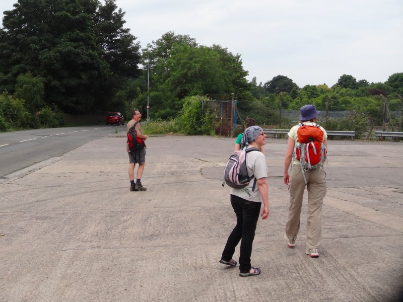
As well as talks by the guests, we had a number of workshop activity sessions including a role play taking a walk to the university duck pond as if it were a hike, and various design/brainstorming sessions looking at the synergies and conflicts between different stakeholders and potential technologies for use on the trail.

My chosen technology would be a small device with physical buttons (not touch screen!) and GPS, possibly integrated into a voice recorder. The buttons could be colour coded and allow you to simply tag a spot from a small pre-determined set (bad path, view, etc.) and perhaps leave a voice note. Later one can go back and add details, but while walking I’d like to just say “this is an interesting spot”, and move on.

One evening there was a small reception where students showed some of the projects they had been doing around the theme. This included cultural probes, text analysis of tweets about various long distance trails in comparison with their mission statements and a touch screen system to explore Ellis and my blogs about our walks.

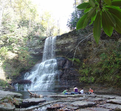
The workshop concluded with a short walk to he t66 foot Cascades waterfall, where the white foam of the falls was beautifully framed by white ice sheets across the rock face.  The photo below from virginia.org is clearly at a warmer time of year!

Reminders

There were so many conversations from things highly germane to the trail, to those more peripheral: Blacksburg’s single-screen, volunteer-run cinema’s Oscar nominee series, the nature of the Red Neck, the American Independence and Civil Wars (in the South, not utterly forgotten), and campaigning in the area at the last presidential election. Of course the latter things are not utterly independent of the workshop topic, as urban ideas of nature as object of preservation and leisure can often stand in conflict to more pragmatic rural connections to the land.

Aside from politics, there were two things I found myself mentioning repeatedly.

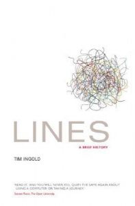
The first is Tim Ingold’s book Lines: A Brief History . Ingold’s thesis is that we have privileged the point or place in modern thought, seeing the connection as merely the means of getting from A to B. Ingold is an anthropologist and spent time studying reindeer herders. Their way of life is to follow the herds as they make seasonal migrations; for the tribes following the herds it is the way they follow, the path, the line, which is primary. Ingold has also edited a collection, Ways of Walking.

The other was MonmouthpediA.

Monmouth is a small county town on the border between Wales and England, but in 2012 it became “the world’s first Wikipedia town”. I am amazed at how few people in academia have heard of the project, indeed I probably would not have myself if it were not for the walk.

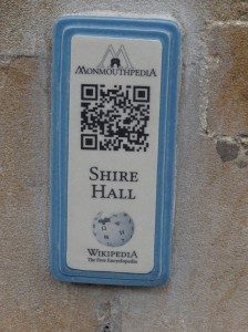
MonmouthpediA was a joint project between WikiMedia and various local councils and agencies, which included creating a special area on Wikipedia with entries for pretty much every building ad location in the town, free WiFi over parts of Monmouth, and, most significantly, small plaques with QR codes everywhere in the town linking to their MonmouthpediA pages.

With the benefit of hindsight I think it would have been better if they had used an intermediary URL, rather like tinyurl, this would have the made it easier to remap codes to content, including, for logged in users, contextually (e.g. children’s content, treasure hunts). However, for it’s time it is truly innovative and I’ve not heard of anything similar elsewhere since.

As far as I know there is not yet a world’s first Wikipedia trail!

Issues and Themes

Reflecting on the various presentations, group workshop discussions and informal talks during the visit, a number of themes emerged for me.

Marks

Part of the Wales Coast Path publicity was that it was “Way Marked”, hence as a rule (see also below) of my walking I followed these first and only consulted the route on a map (another marking) when I got lost from the markers.

Several more experienced walkers I met on the way had walked US trails, or Camino de Santiago in Spain remarked (sic) on the different quality of marking.

Things Ellie said and discussions during the Saturday Cascades walk, emphasised different natures of the laid out, or beaten path on the ground.

Marked and Unmarked Lines

(photo Wikipedia)

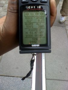
In the UK some long distance paths are waymarked, others deliberately not – you need to navigate to follow them … virtual paths. On Saturday Scott drove us “across the state line” (a phrase repeated so often in films) into West Virginia … a virtual line on the map, but also the road visible changed it’s character. We chatted on the walk about crossing the Equator and Arctic Circle – virtual lines, but ones with some physical identity, and the Greenwich Meridian, a purely arbitrary human line, but in Greenwich marked in the pavement.

The photo shows the Greenwich Meridian – marked on the ground and measured virtually with a GPS.   However, the two differ as UK longitude-latitude is slightly different from GPS long-lat indeed about 100 yards different at Greenwich … measuring where you are on a curvy earth is not straightforward.

Classes/kinds of marks

  • On the ground constructed – blaze, WCP roundels, direction signs, made paths
  • On the ground accidental – worn paths, signs of previous fires, litter, natural landmarks
  • On the map – lines or waypoints
  • Guide books, etc – often through geographic coordinates (remembering that even long/lat have multiple definitions differing by up to a hundred yards on the ground … that’s over a cliff!), but also place names, and landmarks

The latter connects to a chapter I’ve been recently writing about the ways physical and digital (or read more generally imaginary/virtual) worlds are connected (QR codes, etc.).

Absence of marks and knowing you have gone wrong

One thing I noted early while walking was the importance of cues to tell you when you are not on the path. This also has parallels in information systems design – error detection is as important as error recovery, indeed arguably more important as you cannot recover if you don’t know you have gone wrong … lots of links here to undo and things.

Ellie mentioned the frequent white blazes on the trees on the Appalachian Trail, and so, when she accidentally went off trail, she noticed quite quickly because there were no white blazes on the trees.

Note that this relied on the reliability of the waymarks, so that their absence was actually a sign in itself (rather like silence in speech). The lack of this reliability was, in contrast, a major problem on WCP, where they only seem to mark the ‘significant’ points (e.g. where the path exited a large open space), and, in some areas, even these erratically!

I recall one occasion (on the hillside about Fairbourne), where I was following a farm track and came to a gate. Straight onwards the path led beside a wall, but the farm track led through the gate. There was no WCP roundel on the gate, so I inferred that it was not the way to go … a big mistake that led to an hour or so wandering through thick mist on open moorland, criss-crossed with stone walls, that eventually led me round in an enormous circle! (N.B. climbing the walls would damage them, in most of the UK it is this kind of thing, not natural features, which limit navigation)
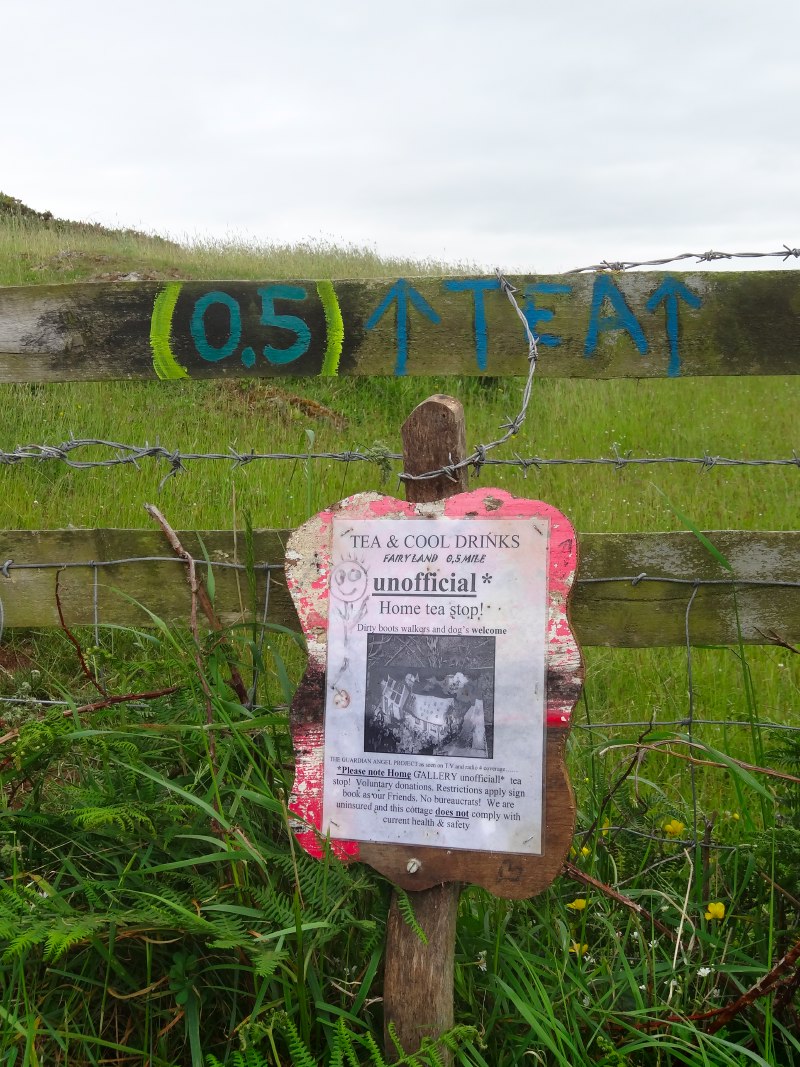
Hidden markers

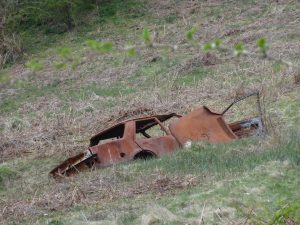
One reason the WCP markers were so small was, I think, so that they did not ‘mess up’ the countryside. Indeed, while I was walking, the Chair of the Long Distance Walkers Association, wrote a letter to members decrying the fact that on a couple of long distance paths, there had been incidents where someone had painted arrows on rocks to help guide walkers. As well as being criminal damage (remembering that there is little truly public land in the UK, only private land with rights of way), it also gave walkers a bad name. Although this was all perfectly correct, it was a point I pondered often as I struggled to find a 3 inch roundel across the far side of a field in the dusk or rain. The countryside is often far from ‘tidy’, full of fragments of baler plastic, discarded farm machinery, just about anything turned into feeders and water containers, and yet many in Britain have an image of the unspoilt rural idyll.

There are also good reasons for hiddenness. When the WCP crossed through built up areas roundels were attached to existing sign posts, but were rightly small as they are not relevant for the majority of people using the place (see meta-semiotics and Stanstead below). Indeed in some places, the normal 3 inch roundels, were reduced to small one inch ceramic disks and embedded into the pavement, very hard to spot even when you know they were there, but deliberately to be overlooked by those for whom they were not relevant … and also hard to vandalise.

I’m reminded too of Gypsy patrins (or patterans) and Hobo signs, which showed whether a house was a good one to beg at, or where other members of your group had gone, but were simple arrangements of stones or sticks that others would miss. The open WiFi chalk marks that sprung up in the late 1990s / early 2000s a similar example.

Rules

Norman’s hunters’ ideas of fair chase meant they created their own sets of rules about what was, or was not reasonable hunting practice. Ellie mentioned how some thru-hikers would not take a short cut when the path meandered up a mountain, or take alternative more scenic routes. I also had internal rules about conditions when I felt it OK to deviate from the set path: when I could get closer to the sea, or when I had got lost and it was ‘their’ fault (as in the WCP developers).

Information (in/about the land)

Rather like the marks for the path, information may be embedded in the land (e.g. the information board on the Saturday walk that told us about the old logging engine), or linked to it and presented elsewhere (guidebooks).

There are of course, digital versions of both these: public displays in location and smartphone apps, etc. linking from elsewhere.

I’ve a draft chapter about this for TouchIT (this chapter not yet online) about the different forms of linking (names, descriptions, QR codes, etc.)

Interestingly one of the distinctions for this is whether the points of linkage are physically inscribed in the land (e.g. QR codes for MonmouthpediA) or external to it (e.g. the PCT Halfmile waypoints).

In a project about ‘non-places’ (French philosopher Auge’s term), we had a meeting at Stanstead airport, and I became fascinated by the way signage sort of told you whether to there to read it or not, the meta-semiotics, of how to read a sign, who was intended to read it or not (see “not for itself: insider/outsider orientation of place and signage and systolic flows” ).

Names of places

This came up multiple times, not least whether a place having a name made it more significant.   … interesting connections to place/space

Flows

Another issue I first really became aware of in the non-places project, is about different flows human and material (I still have the photos of the back of a DIY store where we had another meeting).

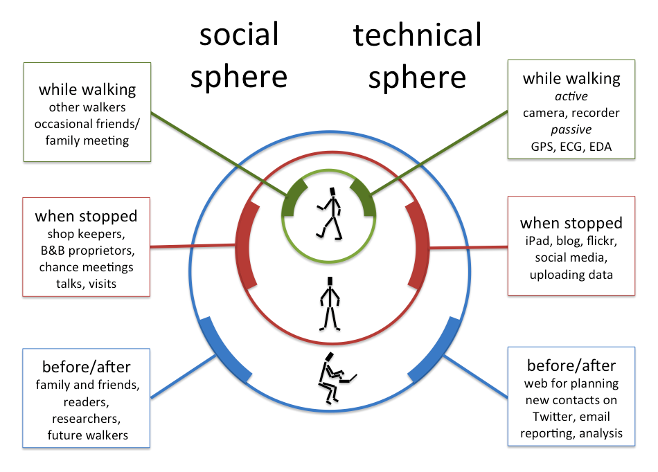
As human flows are in space and time, for unconstrained 2D movements, you may never encounter those whose paths cross yours, but linear trails change this relationship. Passing people going the same way as you are, walking with them for a while, meeting people going the opposite direction, and those who live on the way (shop keepers, campsite owners, park rangers). There are also people who have walked the way before: flows along the same path, but at different times, leaving marks in the wear of feet, log books, guides, and even major motion pictures. This connects to another theme in my past work ‘absent presence’ the ways to be aware of others at the same place but different times.

People

One of the questions asked by a working group was “what are people”, and indeed we later had a workshop session focused laregely on identifying different stakeholder groups with interests about trails.

Here is one distinction (amongst others) that emerged from personal reflection prompted by Stavros Asimakopoulos’ grounded theory analysis of my blogs:

Egocentric/ people of life – These are the walker’s own individual community, linked to his personal existence. They are stable and long-standing, and largely geographically stationary but widely distributed.

Geocentric/ people of the land – These are the local community, people who live in the towns and places along the way. They are linked to a specific place. The relationships are typically fleeting, but the people themselves are largely geographically stationary and localized to the route of the path.

Tribocentric  / people of the way – The walking community, who are connected to the path, not any particular place along it. The meetings are fleeting and the people themselves geographically dynamic. (Note: this is from Greek ‘tribos‘ – a beaten track or path. )


A year ago today

settingoffIt seems hardly possible, but it was a year ago today that I set off from Cardiff at the beginning a three and half month and one thousand mile trek around Wales.  It seems a life away and yet almost yesterday.

It is very odd, for those months I was the ‘walking man’; surprisingly quickly it was as if my whole life had been, and ever would be, on the road.  It was hard to imagine any other life.  Then, even more worryingly quickly, when I finished I returned to ‘normal’ mode, albeit finding it a little difficult to settle and actually doing some of the jobs round the house that had lain undone for years.  Sometimes I feel island events are more recent than they are because my mind has sort of sewn up the edges between leaving and returning.

I feel a little like Dax in Deep Space Nine, who has a symbiont inside her that has been through multiple hosts, she has all the memories of these past hosts, but is very definitely herself.

Last year Easter was quite early and by the time I started walking it was long past with Miriam’s wedding in between.  This year the 18th of April is Good Friday.  Last night we had a Maundy Thursday service in the Church of Scotland which included foot washing.  Today we worry more about smelly feet inside shoes, but in Jesus time it was customary to wash one’s feet before entering into someone’s home as they would be dusty and dirty from the road.  This feels all so familiar, for the main part of the coats of Wales I wore sandals to walk and, at the end of each day, my already sun-darkened feet would be encrusted with a with layer of dust and earth.

When I returned I had meant to spend time ‘tidying up’ after the walk, filing in missed or incomplete day posts, curating data, choosing photos for cards, and finally writing a book about it all.  But of course, when I got back life started again!  I had three months of work to catch up for Talis plus academic things, so progress has been, at some stages, painfully slow.  Really I needed as much time before to prepare and after to write up and report as I did actually walking … but life is not like that and I was very fortunate to be able to take the time out that I could.

However, in the time since I have not been idle.  I have given several talks about the walk, keynotes at APCHI in India, and Aachen in Germany, to masters students in Birmingham and a public talk back here on Tiree.  Next week I’ll be giving another seminar in St Andrews and then going to a meeting about rural issues and technology in India.  I’ve also written up the notes of the APCHI keynote and used that as the basis of an issue-based online report of the walk – lessons learnt and questions to consider.  And of course the issues of technology ‘at the margins’ are just as true here on Tiree;  despite being 500 miles apart, there is a close link between walking in Wales and various technology focused projects I’m involved with here on the island.

When I first returned home last August, I was managing to do quite a lot of the blog catch up.  Initially I was working backwards filling gaps, as I thought it best to do first those days where memory was most fresh; for the earlier days I assumed I would need to use a lot of prompting from photos and the audio blogs anyway.  This then came to a bit of a stall as I was travelling in the autumn and the REF2014 work started in earnest after Christmas.

2013-04-18 14.38.31However, now I am using the anniversary as a forcing function to make sure that each day I can tweet last year’s blog … watch out for tweets and Facebook updates that say:

A year ago today I was ….

And of course a year ago today I was setting of, walking from Cardiff to Nash near Newport, with Andrew accompanying me and seeing the West Usk Lighthouse and Newport Transporter Bridge on the way … and yes, I have now (after a year) complete the day 1 blog.

Oddly, or maybe not so, I am needing far less reminders than I thought, with surprisingly little prompting the memories flood back in step-by-step detail.

The data side has been reasonably well curated (files and meta files, CSV, JSON, and other techie acronyms) and I am having a first ‘Hack Alan’ workshop in Southampton at the end of May, with another in Nottingham maybe later in June.  I’m doing more work on this periodically.

Fiona has been helping me to go through the blogs adding mark-up for ‘semantic entities’, in order to make an interlinked document about the coast of Wales.  Most isn’t live yet, but there are little bits here and there; if you click on Penarth Head in the final day blog (or here!), you get a little ‘semantic pop up’. Eventually this should mean we have nearly 200,000 words of text with entities marked and resolved, including names, places, etc. As well as augmenting the text itself, I hope this will be a useful corpus with a ‘gold standard’ markup for those wanting to do entry recognition, name resolution, or maybe other more sophisticated narrative markup.

sensors-chargingWith 60 days worth of near continuous readings, the biodata is probably a unique resource in the public domain.  One of the goals of the workshop in Nottingham will be to further process this: easy linking to GPS trace and qualitative data, creating heart-rate data from the ECG data, etc.

I also need to learn how to effectively publicise the availability of all this data.  If you or someone you know is interested data for health and fitness issues, life logging, quantified self, semantic web, or any other use of this data please get in touch or simply access it here.

Looking forward I want to spend some more time back in Wales, revisiting places, and talking again with people I met last year and also those that I missed.  During the preparation for the walk, during the walk itself, and since returning, I have met and been in contact with many academics and artists for whom walking and human contact with the land and landscape is an intimate aspect of their work.  So next year I’d like to organise some sort of festival of the foot, or symposium of the human body in the landscape … would you be interested?

… and next year, maybe, my feet will begin to itch again …


health, pain and fitness – does 1000 miles help?

People have often asked me, both during and after the walk, about its impact on my general health and fitness.  The answer depended a lot on the point in the walk I was asked, but now, when my body has had a chance to recover, I can unashamedly say yes, the impact is major, but not necessarily in the ways I had expected.

I’ll spare you the before and after pictures, and give the blow-by-blow account, but as a sneak preview, it ends with 200 push-ups at a ceilidh.

I’ll start with the base point.

I live my life behind a computer screen or the wheel of a car, and for many years relied on a good general level of fitness as a child.  I was never a sportsman, partly because I was not particularly athletic, and partly because I needed to help my mum with her job as caretaker at the church and this pretty much precluded any after school activities However, in my late teen years I would regularly go for a run each Saturday morning in between watching Open University programmes and shifting hundreds of chairs and tables at the church.

As well as regular runs, I used to walk everywhere as a child, as I generally could not afford buses.  On one occasion this involved dragging old mattresses several miles to the local waste disposal site, with only the wheeled frame of a shopping trolley to help.  However I also used to walk for pleasure, out of Cardiff to the hills or sea shore beyond on my own or with a friend.  This would start with an hour or two to get clear of the city before walking in the countryside, and a day of 20 miles was normal.

But that was all 35 years ago.  Since then exercise has gradually shrunk to the tapping of computer keys or dashing back and forth down university corridors, often leaving passers by spread flat against the walls for fear of being knocked over.

When we moved to the island I started to run regularly on the beach for about three months … and then I started travelling again, stopped running and never restarted.  Between that and the walk there were a few sporadic, and maybe precipitous to the point of foolhardy, attempts at exercise.

After 18 months of indolence I was going to be on Tiree during the annual Tiree 10K, so, with a grand total of two practice runs, I entered and, to be honest, while running thought I was not going to make it to the end.  Buoyed by the knowledge that lack of preparation does not guarantee fatal consequences, six months later I cycled the Cumbria–Newcastle coast-to-coast with Miriam, not having cycled up a hill for 15 years.

My next feat of fitness foolishness came six months later again, at the next Tiree 10K.  To be fair this time I started to train well in advance (three weeks), partly because I was to be away at a conference just before, so needed to be able to leap from the plane and run pretty much straight away. In ten days I worked up from nothing to running a half marathon distance (which did amaze me, even though it did take weeks to wash the blood out of my T-shirt); at this point my Achilles tendon had had enough of this treatment and decided to teach me a lesson.

However, while I was indisposed for the spring 10K (the pain of hobbling across Gatwick airport is still fresh in my memory), last December there was a winter 10K on the island.  Avoiding my over-preparation mistake of the spring I returned to my original exercise regime, two practice runs then enter, and survived without intimations of death at any point — clearly the long-haul intermittent hell strategy does have positive effects on the body.

After this I intended to do lots of practice walking through the winter in preparation for the walk, both for body fitness and to get used to walking in bad weather — I spend my life trying to stay ‘comfortable’, I needed some discomfort training.  Well this was the intention, but well … walking takes a lot of time, and I always feel too busy …  the pattern should be familiar by now.  Three weeks before I was due to leave the island I started some practice walks.   Tiree is pretty flat, but there is Ben Hynish with the radar golf ball that sees civil planes safely across the Atlantic.  I intended to practice walking up Ben Hynish, but …

The long and the short of it is I started out walking 1000 miles around Wales with a grand total of two weeks preparation (the last week was Miriam’s wedding).  If I was going to get fit it was going to be ‘on the job’.

I expected some pain early on and then to get fitter and fitter during the walk, so that by the end I would be like a mountain goat gambling up hills as if I didn’t notice them.

To some extent the part up Offa’s Dyke went like this.  Day three was the hardest, long, low on food and water (yep, I know that should never happen to a well prepared walker, I was in the Scouts, I know the theory!), and the first time I had walked any slope for years … and by slope here we are talking just 1 in 10.  Amazingly my actual feet survived the whole way with virtually no blisters.  I used the grand total of two Compeeds (plaster + padding) and three elastoplasts during the whole walk and two of the latter were for bramble cuts.

As expected, by the time I got to the last day of Offa’s Dyke I was striding up Moel Famau, the highest point of the Clwydian Range, effortlessly passing other walkers along the way.  I realised I had become one of those really annoying people who make it all look too easy.

However, any danger of smugness was shattered by North Wales.

The North Wales path from Chester to Bangor is along a flat sea coast, barely rising a few meters for its entire length; indeed for much of the distance it runs along seaside promenade.  I had thought this would be an easy stroll after the hills of Offa’s Dyke, but the flatness was nearly my undoing.  On my first full day of walking I got some sort of tendonitis on the top of my left foot and it swelled up like a balloon.  I think it was due to the regular unchanging nature of walking on the flat, constantly using the same muscles, the same tendons, in the same way.  I swopped into sandals, not knowing if it would help, but worried this might be the end of the walk.  However, the increased flexibility of wearing sandals made all the difference and very gradually the swelling eased.  When a week or so later someone looked at my still slightly swollen ankle and said “you I can’t walk on that”, I said “you should have seen it a week ago”; I felt I’d managed to work through difficulties and win through.

So no longer a mountain goat, but I guess still a little smug.

Not long after, that also changed.  From about the third way point, and especially as I got to half way, things got harder and harder.  Long term strains and pains started to set in, I couldn’t bend at the knees, different joints and muscles would hurt, and the knowledge that I still had as much to do weighed down on me.

Instead of a mountain goat I felt like a geriatric.

Over recent years I have run further than I had as an 18 year old, I can lift heavier weights and now was clearly walking far far further.  But when it comes to repair youth wins; I was doing damage faster than my body could strengthen itself and was seriously worried that I was causing permanent injury.

I was sleepy tired because I was walking, writing and tending technology for 18-19 hours a day, I was physically tired, and hurting, depressed as I wasn’t getting as everything done that I intended, and worrying that I wouldn’t get the miles in to get me back to Cardiff on time (see my poem ‘Tired‘ for a hint of the feelings, written when I was ‘on the mend’, but still feeling the fatigue)

With no mental or physical reserves, the only thing that kept me going was the knowledge that I had decided to do it.

In a race they talk about the wall.  In a marathon it may last half an hour, in an Ironman several hours, but here day on day, week on week, and yet slowly, I came out the other side.

The physical pain did not go away straight away, nor the stiffness, but gradually things got better.  This was partly the result of wonderful people I met along the way, partly that the path got easier (Ceredigion coast path is wonderful), and partly that I did try to take some full or part rest days.

And after the initial worries about getting sufficient miles under my belt, I ended up ‘front loaded’, so that the last quarter of the walk I could average less and less miles each day, and my body could start to recover.  By the time I finished in Cardiff it was really just the soles of my feet that still hurt.

Now, more than six weeks on, even these are beginning to heal and last weekend I did my first two runs since the winter 10K , and it was easy.

I have not forgotten the pain and intense weariness of the middle times and yet, if there were no constraints of work or money, I would start again today, maybe going the other way round, or maybe walking somewhere else.

However, it is not with the slowly healing soreness of my feet that I want to end.

I had expected my lower body to toughen up and my legs and gluteus are indeed firm.  After a few days when my blood sugar dropped I worked hard to eat plenty, so I only lost a little weight, but have clearly converted some excess fat into muscle.  My belly is no rippling six-pack, but under the hair and fat (aren’t you glad no pics) clearly more toned.

I also expected that the inevitable calorie deficit would eat into my upper body if I wasn’t careful.  I deliberately took a Bullworker along so that I could do a little exercise, but never had time and it sat unused.

When I got home I decided to see how my arms had fared through the neglect.  Before I left, if I occasionally did some press-ups I could manage 20 with a struggle on a good day, but that was the max.  But now, when I got down I powered through 20 and at 30 was still feeling fine. When I tried again on subsequent days I got to 40 and then 50 press ups.  It really does sound like one of those food supplement adverts, except instead of ‘instant’ fitness this took 100 days of toil!

I think this is all down to the long-term cardio-vascular exercise of walking.  It is known to be one of the best ways to strengthen heart and lungs.  I wish now I had taken a peak flow meter to see how my lung capacity changed, but hopefully when those who know how to analyse my bio-data look at it, that may reveal some of the changes.

Looking back I also realise just how efficiently I worked during the walk.  On top of 8-10 hours walking each day, sometimes driving or public transport time on top of that and an hour ‘tending technology’ (charging, copy data, etc.), I was also writing around 2000 words a day, that would be a good rate if I were doing nothing else.

A recent study took children with ADHD and tested their attention span after 20 minutes walking.  It was as good as when they took the standard dose of medication.  Physical exercise is as good for the mind as it is for the body.

Finally, and what made me want to write this, was the experience at the HCI conference last week.

On the Thursday evening there was a ceilidh after the conference dinner.  A wonderful band, Modhan, had travelled down from Edinburgh to play for us.

After the first set I we all went back to our places breathless, while the band played a few non-dance tunes.  I was feeling exhausted, but wondered how my strangely altered body would fare when word out like this.  In a secluded corner I arranged some chairs so I was not too obvious and started to do push-ups; the last half dozen were hard, but I got to fifty.  After the next set I did the same and fifty again, then the third set another fifty.  Towards the end of the evening well after midnight a fourth set of fifty, two hundred in total amongst the ceilidh dancing.

I did wonder if this was the effect of the copious wine and that I would be unable to move in the morning, but in fact, the only pain was a soreness in the calves from the dancing.

I am still amazed at this alien body I have been transposed into.

I’m sure you’d get 90% of the benefit from a simple 20 minute walk each day and avoid the pain. This coming year is going to be very busy, so I am certainly hoping I can maintain this unexpected fitness without doing a 1000 mile walk every year.

Indeed signing up for Will (resident Tiree Ironman) Wright‘s autumn circuits sessions now 🙂

… but then there is always 2015

walking again, back on Tiree

Just had a wonderful day walking the length of Tiree.  At just twelve miles just a step compared with 1058 miles around Wales, but still the length of a whole island!

I got back to Tiree just over a week ago, on Monday 5th.  On the way over I had wondered about doing a walk on the island so that some of the people here could join in.

As we drove off the ferry, we passed a few folk we knew walking off and shouted hello through the windows, then Fiona said, “look”, and as I looked ahead (not a bad thing to do when driving along a pier), I saw a crowd of people waving flags, with champagne popping.  It was a wonderful moment and one I had not imagined.

2013-08-13 09.38.41-cropped

setting off (photo Esther Dix)

So, it was lovely to be able to share a bit more of the feeling of the long walk, by walking the length of Tiree.  With the Coll Half Marathon and 10K next weekend, there wasn’t going to be a perfect time for everyone, but eight of us walked together, some for the whole way, some having to break off for dentistry or conserving feet for the 10K on Saturday.

We started in Caolis at the North East and walked on roads and beaches, within lunch sat outside Dorinda’s gallery in Scarinish, a quick cuppa at my house in Crossapol and then finished down at the Skerryvore Lighthouse Exhibition at Hynish.

During the walk we talked a bit about the combination of commitment and perseverance that has to take over when physical and mental endurance fail, and Dorinda told me about the people of Galacia in Northern Spain, another Celtic area, whose traditional dress is just like in Wales.

Radio Wales interview

A resting day (wow!), with just a short trip back to Barry to pick up the van.

Esther left by train on her way back to Liverpool, and Miriam and Oliver driving back to Birmingham, so celebrations coming to an end … real life soon!

However, this afternoon I had a short interview at Radio Wales on the Good Evening Wales show.

I found the whole process fascinating and very efficient, the gap between being picked up to when I was back at the hosue was barely an hour.  At the studio there is a control side and the room with the presenters in.  In the control part Louise, who had talked to me by phone eaelier to set up the interview, sat with two others each with two or three computer screen search.  High on thew walls large screens showed news stations on silent, the ticker0tape announcing breaking news.   I’d have liked to find put more about the different roles, but they were in the middle of broadcasting, and obviously doing various coordination jobs centred around, what I think was, a timeline of the programme.

Nelli Bird talked with me in the studio with Gareth Lewis chipping in.

Nelli had interviewed me by phone at the beginning of the journey in April, while I was sitting on a wooden bench at the back of an industrial estate between Newport and Nash.  She is a Newport lass, but I had to admit that I was doing Newport first not because it was the ‘best bit’, but rather I was ‘getting it over with’ first.  I should add, that I learnt lots of good things about Newport that day!

We talked mainly about the issues of poor mobile and broadband access across Wales, the impact on education and general inclusion.  Garath said that maybe sometimes it is better not to have Twitter access, which is absolutely right in the middle of a wild area.  However, the Arab Spring and similar movements elsewhere have shown that Twitter and other social media give people a voice; if people in the Welsh margins do not have effective access, they they effectively become voiceless.

The full programme can be found on the BBC Wales website here (streaming, see 1:15:25), but I have also made an extract of the interview (mp3).

Day 102 – Penarth to Cardiff

homecoming to classic Cardiff weather, the end is a beginning

28th July 2013

miles completed: 1058
miles to go:  0 — Finished!

Three miles to go, a simple morning stroll.  In fact, given the weather forecast, perhaps we should have walked across at eight and had breakfast in Cardiff.  However, that was not the plan.

Fiona and I had spent the night at the Pier Hotel in Penarth, and at various points between nine and eleven, several people joined us for breakfast … some closer to eleven: Esther, Janet and Rachel joined us first and then later Zac and Candace brought Miriam and Oliver, having negotiated confusing roadworks in Llandaff and then Penarth, which includes going the wrong way round a roundabout.

At eleven I went down to the Pier and Andrew was there to walk the last day with me as he had walked the first.  And the rain started.  By the time the rest had joined us, after packing cars and finishing breakfasts, we were already a slightly dripping crew sheltering under the canopy at the pier head.   There were eight of us as Zac and Candace were not walking, but were going to drive round and meet us in Cardiff Bay.

So the final three miles started in classic South Wales weather; the rain poured.

We made our way over Penarth Head up stairs, then along Victorian terraces, with occasional views of the sea or of Cardiff ahead, all in surprisingly good spirits given the rain soaked every inch of our bodies, finding ways to sneak through unsuspecting gaps in waterproofs, or simply swamp them with its volume.

I was wearing my hat for this last day, but, worn and bedraggled I felt rain gradually dribbling down through the top onto my head, and starting to fill up above the seal between brim and head.

After a short while the path drops down towards the marina, where Janet and Rachel, who had popped ahead to find a shop, were waiting.

There is an imposing building, which, I guess, used to be the port office and is now a restaurant, the marina with a waterbus just arriving and then the expanse of the barrage stretching out ahead.

I was trying to take some photographs, sheltering the camera from the worst of the rain, but had to give up.  I must go back sometime, as I had never seen the barrage up close before, and the engineering is impressive, first a bridge and lock, although I did not spend a lot of time examining its mechanism, as I normally would, then what I think is a large adjustable weir to control the level of water in the Bay, and finally, after that, two large sail-like structures, huddles of sodden people sheltering in their lee, where the barrage becomes more of an earthy causeway.

Although the forecast had been for rain, and the previous day had rained, the majority of people were in summer clothes, whether in the perpetual state of British summer optimism, or simply not having adjusted to the break in the heat wave.  Although, the British are never totally unprepared for the weather, and there were many umbrellas over dripping summer tops.

I recall the first term I went to university in Cambridge. On the dry east coast it rained about twice.  I had a six week Christmas break and planned to do some repairs to the back door of Mum‘s kitchen over the break.  I had forgotten Cardiff weather.  It of course rained every day of the entire six week break.

I had expected days of rain like this during the last few months, to have to walk when the rain went on continuously from morning to night; this is Wales.  Instead I have had amazing weather with only six days of proper rain and then no day that was utterly unremitting, some days, as when I walked Church Bay to Holyhead, starting with heavy rain and then easing in the afternoon, some days, like Holyhead to Rhosneigr, starting bright and then turning to rain later, some, like going over Moel Famau and the northern Clwydian Range, with horizontal hail, but then alternating with bright and clear periods.

However, the weather decided I needed reminding that indeed this is Wales and Cardiff to boot, and so upped my rainy days quota by 33% in the final two days of walking.

Part way across there was a useful public toilet, of which those who had had serious amounts of coffee at breakfast availed themselves, while the rest gained what shelter they could against its walls, and then the final walk past the new Dr Who exhibition, where, just in time to let me photograph the Tardis by the waterbus stop, the rain broke and the blue skies that seemed to be to either side, but not over us, did eventually catch us up.

The last half mile was, well not in absolutely glorious sunshine, but bright and, compared with the hose-pipe-like torrential downpour as we crossed the exposed barrage, dry.

But we were early, as we got to the Norwegian Chapel it was only twenty past twelve.  The three miles on the official mileage charts feel as if they are definitely rounded up, and, with heads down and few stops to take photographs, we walked quickly.  We didn’t want to get to Cardiff Bay too early as Zac and Candace were meeting us there and also Rosie had said she was coming, and we had tweeted 12:30 to 1pm.  We didn’t want someone who had come to meet me miss me arriving.

So, for a few minutes, we dawdled near the Norwegian Church, built for Norwegian sailors on their visits to the docks, and Andrew and I took a look at the lightship, that once was moored in the channel to guide ships into the ports of the Bristol Channel, but is now permanently moored, and, if I recall, is some sort of Christian centre.  Near it is a tea, coffee and sausage van, but having had a very big breakfast at Pier Hotel, I resisted the temptation.

So, after dawdling for fifteen minutes, it was after half past twelve, and we slowly walked towards the Merchant Navy memorial, in front of the Welsh Assembly, where I had begun, three and a half months, 102 days, ago.

Zac and Candace had been sheltering under the huge canopy of the Assembly and took photos as we approached, and then more photos, and we opened two bottles of champagne at the memorial.

Rosie wasn’t there, but it turned out was at the Scott Exhibition; she had been at the end some time around twelve thirty, and then came along the barrage in the opposite direction, I’m guessing missing us when I was looking at the lightship, so for the third time we managed to miss each other along the path.  She had completed the coast path only a few days earlier up at Chester and then drove here on her way back down to the South East (of England).

So, that is it, the walk ended, but more celebrations for birthday and of the completion of the walk over teas, coffees, cakes and moussaka at the Norwegian Church cafe, Jaspers at Llandaff and the Bosphorus on Cardiff Bay.

It is odd, for three and a half months I have been ‘the man who is walking round Wales‘, and that has become who I am.  It feels odd to shift from being ‘Alan walks Wales‘ to simply ‘Alan‘.  Of course that is part of the point, although I end up where I began, things have changed, the location is the same, but I am not the same.

For 102 days the future has been to some extent mapped out, where I would be, and approximately when I would be there.  However, that presages a time of more openness.  I know some things that will happen in coming months, not least catching up on my work for Talis, including working on the online HCI course for a fresh autumn run, completing the TouchIT book on Physicality, and lots of data curation and writing relating to the walk.   But there will be more, everyone asks ‘what next’, and the question will hang there awaiting an answer; at the risk of nearly quoting Terminator, the future feels more open than it did when I started.

Day 101 – Cadoxton to Penarth

and then we were five

27th July 2013

miles completed: 1055
miles to go:  3

2013-07-27 11.22.03Clare Hooper had joined me in Penarth to walk with me today, so after a relaxed breakfast at the Premier Inn in Barry, we caught the train to Cadoxton two stops down the line.  There Fiona, Janet and Ted were waiting for us.  I hadn’t known Ted would be there and it was wonderful to see him, he had met me briefly on my first day’s walking and had come again to join me near the end.

I displayed my superior navigational skills to the assembled masses, by confidently leading us down into the subway to the next platform, but quickly corrected this to the pathway down to the road and join the coastal path.

By walking to Cadoxton the morning before I had cut out some of the road walking, but there was another mile or so through town streets and past a chemical plant.  Ted works for the company that runs the plant and explained that the towers were the tallest in, and now my memory fails me, certainly the UK, maybe Europe.  The plant is shut down at present for annual maintenance.  Ted explains that it is better to have a single scheduled maintenance period, than risk closures while in operation.

2013-07-27 11.11.07As we walk past the plant, on the one side small horses rush up in the hope that we have something to eat, but as a warning against their importunate nuzzling a sign reads:

Please
Do Not ^ horses
     feed
Anything

The kerbstones proudly announce that they are not stone, but instead, “Enviro-Kerb. The recycled composite curb drainage.”

Eventually, we reach the sea, sadly Cardiff-side of the dinosaur footprints.  Later we meet a local man, Linus, who told us that there were alternate ways through the docks which allowed you to walk more of the coats, but the port authority had resisted the Wales Coast Path leading through the docks.

As we look down the coast Sully Island, joined to the mainland at low tide, already looks close, and Steepholm, which has been visible for some days, is less indistinct although still some way off in the middle of the Bristol Channel.  As we walk, Flatholm appears, apparently between Sully Island and the mainland, although in reality much further away and further out to sea.  Both were fortified during the last war, and I’m sure there used to be day trips to Flatholm, although I never went.

2013-07-27 11.52.51We met Linus a little way along the coast at Sully, after the path had passed in front of some houses, a playing field and then some more houses, and appeared to be about to cut inland.  We knew there was a short zig-zag inland coming up, so we almost followed the road.  Happily, Linus saw us and pointed out that from the other direction the coast path arrow appeared to point to the sea.  In fact the post had been removed and reinstalled as part of some building work and the builders had put it back the wrong way round.

A short way after we got to the point where the path really did do its little zig-zag, along the edge of a small field, where the diminutive coast path roundel would have been all but invisible if not for a large sign that said, “End of the Footpath”, with an arrow pointing the way to go, just beyond which we found the ‘Captain’s Wife‘ where we stopped for lunch — indeed, the only eating place in the ten miles between Barry and Penarth.

2013-07-27 12.18.19The story is that the ‘Captain‘ who lived there kept the body of his wife in a box after she died.  Some time afterwards thieves broke in and, thinking it a treasure chest, stole the locked box.  The story ends there and we are left to imagine the distress of the Captain (although I’m sure modern counsellors would see it as a way to ‘move on’) and the shock of the burglars when they opened the box.

Just beside the Captain’s Wife is the clubhouse for Swanbridge caravan site.  When we had one of those ‘what did you do over the weekend’ sessions, one of the boys in my class  at junior school, used to talk a lot about going to their caravan (a bit of social one-up-man-ship), I thought at ‘Swanage‘ … a bit of a long drive for the weekend.  I have a feeling I had realised my mistake in the past and then forgot again, and it was only when I looked at the map in recent days that I realised it had been ‘Swanbridge‘, just a few miles from Cardiff.

While we started our lunches (they had real toad-in-the-hole), the rain started, and poured.  Everyone who had been eating and drinking outside rushed inside, and whether it was the swelling numbers, but the efficiency plummeted in Fawlty-esque fashion.  On the menu there was a coffee plus a mini-pudding option, but the coffee machine was broken.

“No problem, we wanted tea with it anyway,” we said.

But the waitress replied, “we have no hot water either.”

2013-07-27 11.43.19

We assumed this meant that they normally make tea using the hot water from the coffee machine, but felt it surely was not beyond the bounds of culinary possibility to boil water on a stove.

A little later the waitress returned to explain that the brulée torch was not working.

Happily, the puddings that were available were nice, and as we finished them there was no further excuse not to go out into the wet.  At this point Ted had to leave us to go back to his car in Cadoxton, it had been lovely to have him with us and to compare notes with his own walk round Wales, in stages, twenty years ago.

The cliff walk had to divert down a small lane and then across fields to avoid a small caravan park.  The soil from the fields, newly wetted upon a dusty, dry and cracked surface, clung damply to our boot, sandals, feet and trousers; each step made us taller until our footwear resembled 1970s platform boots, and we attempted to scrape off the clinging mud on every sharp corner of wood or stone we could find.

2013-07-27 15.36.09Back on the cliff-top path, not quite as clingy as the field mud, we found ourselves at a substantial WW2 anti-aircraft gun emplacement, the concrete bases, and old metal door and gun fixing points all that remains of a time when Luftwaffe bombs rained on the strategically essential docks.  I recall Mum told me tales of the excitement when a food boat docked raising hopes of luxuries such as bananas.

For a while a section of WW2 concrete path also helped us on our way.

We pass the ‘Marconi Holiday Village‘.  This is the site where Marconi sent the first radio message across the sea from Lavernock Point to Grassholm.  The holiday village sign was the only reminder of this historic event.  Where is the information board at least?

2013-07-27 15.54.53

Along the way is a small castellated building with an entrance, partially boarded up with broken plywood.  Inside the remnants of electrical equipment cling to the walls and two huge grey valves suggest some underground water course, maybe sewerage or maybe fresh.

And then, very soon, the first glimpses of Penarth Pier and Cardiff Bay through the trees, before we come to open parkland in front of expensive sea-view houses, the old metal cliff top railing, backed by a new post and wire fence where the cliff is clearly becoming unstable.  Here, as in so many places, the ever-shifting nature of the coast is evident.

The Pier, which dominates the view, would once have been a place for day-trips and ferries across the channel towards Weston-super-Mare.  Indeed I recall once as a child going on a trip almost all the way across, but not landing.  Maybe even then the Weston end pier was not in service, and I’m not even sure whether the trip went from Penarth, or Cardiff Docks.

2013-07-27 16.41.29Past the park-side bistro (also the place to go if you wish to pay for golf putting), we drop down the road to the Penarth prom, which has building work for new apartments, but otherwise is surprisingly like I recall it from forty years back.

However, at the pier I did have the disappointment I had been steeling myself for.  The Thayers kiosk has gone.  The girl at the current pier-end kiosk explained that Thayers had gone into administration and been swallowed up into a parent company.

So, then up into town to the rail station to have a quick cuppa and cake at Foxy’s Deli  before Clare‘s train back to Southampton and Janet being picked up by Rachel, who dropped Fiona and I at the Pier Hotel where we spend the night looking out on the typical South-Walian rain-greyed sea.

Day 100 – Barry to Cadoxton and MHA visit at Penarth

a short walk and meeting nonagenarians

26th July 2013

miles completed: 1047
miles to go:  11

The main thrust of the day was to visit the Ty Gwyn and Morel Court MHA homes in Penarth, but instead of taking the train from Barry Station, I walked the two miles to Cadoxton to make the next day slightly shorter.

2013-07-26 07.50.25The walk from Barry to Cadoxton starts along the side of the Barry west dock, which is now no longer a commercial dock, not an ‘Oil Storage Teminal’, as is still shown on the OS map, but now the site of dock side residential development.  I would not be surprised if it becomes a fully-fledged marina in due course.  From building signs there will be more development in the area between it and Barry Island, in the area that I recall as the railway engine graveyard.

2013-07-26 07.58.01Further east are commercial and industrial buildings clustered around and beyond the east dock, and my photos for the walk seem to be a mix of the abandoned quayside ironmongery, industrial views and the clock tower of, what I take to be, the massive Victorian dock offices.

Barry, like so many South Wales ports, developed in the 19th century to serve the coal and iron industries, but was created a s a sort of queue-buster.  One of the valley’s steel magnates got tired of having to wait for his ships to get into Cardiff Docks, so simply built his own at Barry.

During this stage I learn the word ‘revetment‘ from the signs that read:

Danger
No Access
Keep Off
Revetments

However, I can’t help but feeling that a warning using a word that no-one but an expert in marine engineering will recognise is somewhat less than user friendy?

2013-07-26 08.02.49After the waterfront walk, the path then goes along the new Millennium Way, a mile-long avenue, the high spots of which include the rusting railway signals, the Victorian villas on the high road overlooking the railway, and occasional glimpses, through the trees, of chimneys in the industrial area.

Although going through such areas is part of the nature of the walk, I am glad that I did it on my own and reduced the road walking for those joining me tomorrow.

2013-07-26 10.11.01I took the train from Cadoxton to Cogan Station on the edge of Penarth where I met Keith Albans, who is going to take me to the MHA homes, but not before a lovely breakfast at Elbo’s in the centre of Penarth.

We came to it by accident as it was just opposite where we found a parking space, but is a lovely place that seems to bridge the gap between ‘caf’, ‘cafe’ and coffee house.  The clientele included workmen, little old ladies and more hip (if that is not an old fashioned term) young people.

The first home we visited, Ty Gwyn, is a residential home for those with medical needs, some with strokes, others simple frailty.  It is on a wonderfully converted Victorian building and had been a private nursing home for many years until MHA bought it 10 years ago.

2013-07-26 12.26.56As well as talking with various residents, the manager told us about the way some of the residents were using computers to communicate with relatives via Skype.  One lady who was terminally ill was taken to the computer where she was able to talk to her son overseas just days before she died.  Now they also have an iPad allowing more infirm residents to communicate from their beds.

While few, if any, of the residents would use a computer freely, they can make use of specific facilities if a carer sets up the Skype call.  In some ways this is a bit like transport, you don’t have to be able to drive a bus to be able to have a day out.  Similarly, there is no reason why effective use of IT need not be mediated by another person.

As we chatted to one of the carers, she showed us the small handheld Psion device that is used to keep track of medication.  She told us how it helped reduce the risk of medication errors and also prompted when a patient’s medication was running low.  I recall first seeing the use of this kind of thing many years ago in a state of the art EU project in da Trofa Hospital in Portugal, so interesting to see this now part of normal practice.

2013-07-26 10.57.21The home has no proper garden, but they have turned a tiny yard into a beautiful ‘secret garden’, which residents have decorated with painted stones and planted with flowers and vegetables.  It was hung with bunting and had tables with parasols for garden parties.

Chatting with residents and looking at the pictures made me aware again of the need to allow those well beyond even increasing retirement ages to be active in productive ways.  Many people are failing in physical health, but have still a wealth of experience, knowledge and skills to offer.

2013-07-26 15.01.02Morel Court is a newer home. It is a residential home, but for those without any serious medical or mental needs, beyond the normal mobility problems of age.

I met one resident who had fund raised for MHA for many years, visiting one of their homes in North Wales, but with each donation she sent, she added a note saying, “why not have a home in South Wales?”  MHA obviously listened and Morel Court was the first of several MHA homes in South Wales, and the lady who collected was here for its opening and then later came here herself, now being the longest-staying resident.

We had lunch in a dining room with a large picture window looking out to the front garden and street.  In a way it was restaurant-like, but the family atmosphere made it feel more like home.  We ate at the largest table, where the residents laughed a lot, and during the visit we both heard plenty of laughter ourselves and, from the stories we were told, it seemed that there was laughter everywhere, in lifts, in the reflexology room, in the jacuzzi, and during games and activities.  One of the residents who is a Welsh speaker complained that the others thought it unfair to use Welsh words in Scrabble 🙂

The home also had a lovely garden, with a large residents’ vegetable bed and even chickens for eggs, although they needed to be put away each evening for fear of urban foxes.

I was still in deep conversation with lady telling me about her childhood in Shrewsbury, when it was time to go.

2013-07-26 15.48.09Back in Barry I wandered up to the High Street that is a lovely combination of small independent and yet contemporary shops, not frozen in time, like Kington, but not succumbing to the mall-ification of most town centres.  Maybe the closeness of Cardiff has saved the town centre from the invasion of the chains, allowing it to prosper more like the small shopping streets that are still found in areas of Cardiff, like Albany Road and Wellfield Road near where I was brought up; the sort of places you go for daily shopping needs, with occasional forays to the big city centre shops.