a walking Wales Christmas

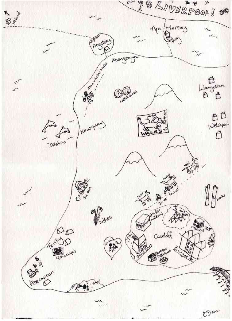
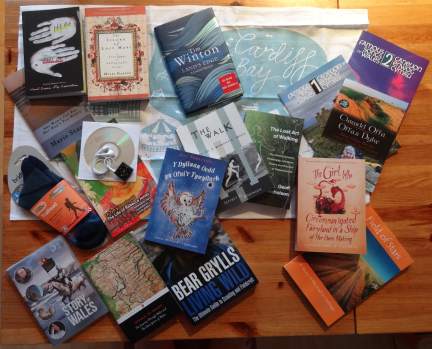
I’ve already blogged about the hand-drawn map that Esther gave me for Christmas, and said that many of my Christmas presents were connected with the Wales walk … well here are the rest!

Most are books, some about walking, journeys and the coast, some about Wales and some to help me learn Welsh (I did some in school and even went to Urdd camp in Llangrannog one year, but really only a smattering).  I’ve not read any of them yet, except “The Valley, The City, The Village“, which is missing from the photo above as I am part way through reading to and it is by my bedside!  So hopefully I’ll have more to say about each when I get beyond their covers and flicking through.

Here and There: A Curious Collection from the Hand Drawn Maps Association. Kris Harzinkski.  A book about individual maps, like Esther’s, from back of the napkin sketches to works of art.

She Won’t Get Far Her Bag’s Too Heavy. Marie Stamp.  A woman’s walk around the South West Coast Path, with just her dog and a (heavy) rucksack.

Y Dylluan Oedd yn Ofni’r Tywyllwch. Jill Tomlinson (trans. Meinir Wyn Edwards).  A Welsh translation of “The Owl Who Was Afraid of the Dark“, which we read endlessly to the girls when they were little — hoping I can get my Welsh good enough to read this!

O! Tyn Y Gorchudd / The Life of Rebecca Jones. Angharad Price (trans. Lloyd Jones).  A prize winning short novel with parallel text in Welsh and English … somewhat more advanced language than “Y Dylluan Oedd yn Ofni’r Tywyllwch”!

The Island of Lost Maps: A True Story of Cartographic Crime. Miles Harvey.  The true story of a map thief.

The Girl Who Circumnavigated Fairyland in a Ship of Her Own Making. Catherynne M. Valente.  Well apart from being fairyland in a ship rather than Wales by foot … just like me.

Land’s Edge: A Coastal Memoir. Tim Winton.  A celebration of the shoreline.

Field Of Stars: A Story of the Road to Santiago. Susie Tarver.  This ancient pilgrim’s route from the South of France and across the North of Spain is one of the world’s great walks and a personal and spiritual journey as well as a physical challenge.

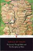
Gerald of Wales : The Journey Through Wales and the Description of Wales. L. Thorpe (trans.) The journal of Giraldus Cambrensis’ missionary journey through Wales in 1188.

The Lost Art of Walking: The History, Science, Philosophy, Literature, Theory and Practice of Pedestrianism. Geoff Nicholson.  A broad sweep through the idea of the walk.  In some way’s covering similar ground to Solnit’s “Wanderlust“, but I think Nicholson will be a little more down to earth and certainly a different perspective.

The Walk: Notes on a Romantic Image. Jeffrey C Robinson. A literary criticism of the literature of walking.  The book includes an afterword by Roger Gilbert, which describes how he was initially dismayed on hearing about Robinson’s book as it was a topic he was working on himself, but then was enchanted by the book when it arrived.  I looked up Gilbert’s web page and found that not only had he gone on to write about the literature of walking, but had co-edited a book “The Walker’s Literary Companion” with Robinson.

Clawdd Offa / Offa’s Dyke. Alun Wyn Bevan.  My own walk will start by going up Offa’s Dyke.  This short dual language booklet relates Bevan’s own walk along Offa’s Dyke and for me both a guide and more help with my Welsh.

Famous Songs of Wales: 1 / Caneuon Enwog Cymru. arr. John Hywel.   Famous Songs of Wales: 2 / Caneuon Enwog Cymru. arr. Sioned Webb.  To be Welsh is to sing!

Living Wild: The Ultimate Guide to Scouting and Fieldcraft. Bear Grylls. In case I find myself without a B&B in the wilds of Colwyn Bay and need a makeshift shelter of old fish and chip packets.  This book has already proved its worth, as I quoted from it at a church service last Sunday; as well as being an ex-SAS serviceman and Chief Scout, Grylls includes a short but direct account of the importance of spirituality to his life.
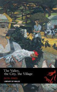
The Valley, The City, The Village. Glyn Jones.  A story of growing up into adulthood set in the Welsh valleys and through university in ‘the city’ (I think based on Aberystwyth).  Sometimes almost Dickensian in the detail of description, but with more the eye of a poet or indeed almost the artists eye of the protagonist. … and I needed to keep OED to hand as occasionally the English vocabulary is stretching 🙂

As well as these books and Esther’s map, I had some walking socks, a Cardiff Bay teacloth, a DVD of the BBC/OU series “The Story of Wales“, which we missed when it was on, and a little black iPod shuffle.  The iPod is for my training walks during the winter and Fiona also downloaded the lessons at Say Something in Welsh for me to listen to whilst walking 🙂

maps of the imagination

One of the main headings for this site is ‘maps‘, as they are both core to any real walk and also things of such wonder in themselves.  Not unexpectedly a number of my Christmas presents have been related to the Wales walk, and I’ll blog about these later.  However, one of them is a map of Wales, hand-drawn by Esther.

Just as I talk about in the page about maps, this is not a ‘standard’ map, not an attempt at cartographic verisimilitude, but more an open story of places and incidents, rendered from memory.  Tenby is north of Aberaeron, and Liverpool (with Wirral elided), where Esther now lives, extends across the whole length of North Wales.

On the map mountains are dwarfed by Janet and Rachel’s dogs, and Cardiff is represented not by the Castle, the Millennium Stadium or the City Hall, but instead by Bangor St where I was born and brought up, Daviot St where my mum lived for after selling the house, and the hospital where we took Esther as a tiny child running a temperature of 103 degrees (Fahrenheit not Celsius!).  Stone throwing seems to be theme with both the stone I threw as a child that saw my sister rushed to hospital for stitches to her nose and also the stone I threw at the school wall, but missed and hit the window.  What I never told the teachers was that I’d seen something about erosion on television and thought repeated stone throwing would reduce the school to a beach allowing is to make sand castes all day – never think small.

Esther’s map reminds me of medieval maps, like this 13th Century map on the cover of the  Penguin translation of Gerald Of Wales “The Journey through Wales and The Description of Wales” (another Christmas present!).  On this map, Wales extends almost to the current Scottish border, with the whole of Cumbria and Lancashire reduced to a vestigial headland.

Maps are always interpretations, focusing on what is important to the cartographer and reader, whether roads and towns, or lighthouses and anchorage depths; memories of places once known and promise of visits to come.


First talk about the walk

Preparations for the walk are progressing slowly, partly because logistics is, well, not exactly my core skill, but largely because I am trying to do everything else I would have been doing over nine months in six.

However, on my last few mainland visits I have begun to talk with various people in Wales and elsewhere, and I’m sure things will work themselves out when it comes!

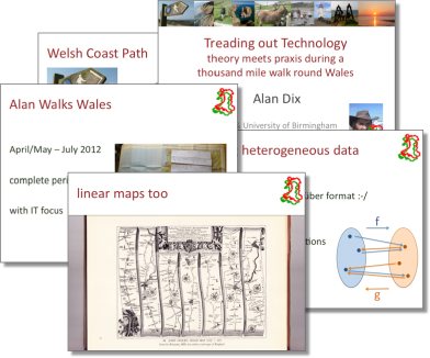
Part of my last trip included a trip to Swansea where I gave my first presentation about the Wales walk, “Treading out Technology: theory meets praxis during a thousand mile walk round Wales”, at the FIT lab. (abstract below).

As well as seeing old friends including Parisa and Harold, I also met Andrew Morgan who is doing a PhD at Swansea Met on circular walks and community use of mobile applications on the Wales Coas Path, and also John Ashley who writes  a regular column on local walks in The Bay Magazine1.  John has recently published a book “Ashley’s Walks” based on the column. The walks are gloriously illustrated with own photographs and sprinkled with local history.

“when a Gowerman said “I’ll zi’thee at Faayer”, it was an invitation to a drink … but … “I’ll zi’thee at Penrice” was a challenge to a fight” (Ashley’s Walks, p.31, quoting H. Tucker, Gower Leanings)

One of the things that has been taxing me is how traditional paper maps, guidebooks and other location related materials can be linked with mobile experiences, not to replace them with an e-alternative, but to combine the richness of turning pages with the utility, interactivity, and availability of mobile applications. Maybe John’s book would be a place to start.

Talk abstract
Treading out Technology: theory meets praxis during a thousand mile walk round Wales

Next year I will be walking around Wales following the Wales Coast Path that opened this year and Offa’s Dyke long distance path up the borders.  This is partly a personal journey reconnecting with the country of my childhood, but also a technological journey investigating the IT needs of the walker and the local communities through which I pass. Some of this will be mundane technologically speaking, but hopefully transformative in practice.  However, I also expect to be pushed to the limits cartographically and theoretically.  In particular, aspects of Semantic Web and the odd Galois Connection will be essential parts of the need to synchronise data between heterogeneous sources and following disconnection.

  1. That is Swansea Bay, not San Francisco Bay![back]

Ian walking up North

Just read Ian Sommerville’s blog about his walking challenge next year.  He is doing the TGO challenge, across Scotland in two weeks in May.  While I’m sauntering round the coast of Anglesey, he will be cutting straight across the Scottish Highlands.  Looking forward to hearing about his planning and progress.

is the Welsh coast fractal?

In my earlier post ‘measuring it out‘, I wondered how fractal the Welsh coast is.

Shortly after writing ‘measuring it out’, I found a GPX file for the Welsh Coastal path at the Long Distance Walkers Association (LDWA) site, and realised, as well as being useful for many purposes, it would enable me to precisely measure the fractal dimension of the Welsh coast (or at least the coast path).

Fractals are those shapes that are sort of similar however much you magnify them: the way individual branches or twigs, may look like a whole tree when set in a miniature landscape.
Mandelbrot’s original work on fractals1 was motivated by the question “How long is the coast of Britain”.  The problem, known as the “Coastal Paradox“, is that as you look at smaller and smaller scales, you see smaller and smaller features and hence get a larger value for the length.  He suggests, based on earlier data of the cartographer Richardson2, that coastlines are self-similar – each magnified part has similar properties to the whole.  In Mandelbrot’s own words:

“Geographical curves are so involved in their detail that their lengths are often infinite or more accurately, undefinable. However, many are statistically ‘‘self-similar,’’ meaning that each portion can be considered a reduced-scale image of the whole. In that case, the degree of complication can be described by a quantity D that has many properties of a ‘‘dimension,’’ though it is fractional. In particular, it exceeds the value unity associated with ordinary curves”

The characteristic feature of a true fractal is that the length measured increases inversely as a power of the length the ruler used to do the measuring.  A smaller ruler means a bigger length, but with the precise rule:

L = K x R1-D

Koch Snowflake
(first four iterations)

The constant D is called the fractal dimension of the curve.  In the case of a smooth line or curve it is precisely 1, in the case of a space filling curve such as the Hilbert curve it is 2 and for the Koch ‘snowflake’ it is approximately 1.2623. If you then plot fractal curve length vs. ruler length, you see a straight line with slope 1-D.  Mandelbot, using Richardson’s data, and others, have found that the fractal dimension of coastlines of countries vary between about 1 and 1.3, with the fractal dimension of the west coast of Britain (a quite intricate coast) is about 1.25.

The GPX file on the Long Distance Walkers Association (LDWA) site has 14500 points marked over its 870 mile length; that is, on average, a point approximately every 100 yards (or metres).  This is almost certainly at a finer scale than Richardson considered in his work, which according to Shelberg et al.4, used ruler lengths of between 10 km and 1000 km for measurements.  In 1961 Robertson had to set a dividers to a scaled length and then walk the length of detailed maps.  In 1982, Shelberg and colleagues had to hand-digitise coastlines and then analysed them using computers one million times slower than those today. Doing the same analysis now, the slowest thing is parsing the XML of the GPX file to get the long-lat coordinates of each point, it is easy to get rapid results at a far finer scale.

So, is the Welsh coast fractal, and if so what is its dimension?

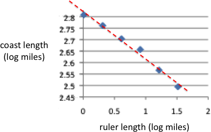
The figure below shows a log-log plot of the measured length against the virtual ‘ruler’ length from 1 mile (log = 0) to 32 miles (log ~ 1.5).  The red line has a slope of -0.2 suggesting a fractal dimension of 1.2, a little smoother than the whole British west coast (which includes the incredibly intricate west coast of Scotland), but toward the upper range of typical coastline fractal dimensions.

So, looking at this, yes, the Welsh coast path is fractal with a dimension of 1.2 … except …

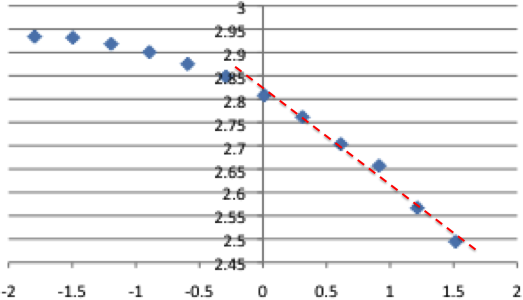
… the average distance between points in the GPX trail is about 100m, with the smallest features around 25m.  The graph above only shows the upper end of distances above 1 mile, if the fractal analysis is extended as fine as possible, the curve starts to look very different. Here is the full graph including the ‘ruler’ lengths below one mile.

This now looks very different, with the points curving down to the left (smaller rulers) well below the straight line fitted to the larger ruler distances.

Now the first point or two represent features below the average point distance on the digitised GPX trail.  These are probably places where the path is particularly curvy, so are probably reasonable to include.  However, to be on the safe side, ignore the first two or three points.  Still, the graph is far from a straight line; that is it appears not to be truly fractal at all, smoother at fine scales than a true fractal would be.

Given the iconic nature of coastlines in the early fractal literature, this seems a little surprising, and indeed one can start to think of reasons for this.  Paths by their nature probably smooth out features.  However, this is the coast path, and following it on the official maps, it clearly does hug the coast as closely as possible; smoothing may happen at distances of a hundred yards or so (the bottom two or three pints on the graph), but not at distances between a few hundred yards and a mile, which are already dipping well below the straight line. Of course, the GPX file may not be accurate and ‘smooths’ the data, however, the inaccuracies needed would be several hundred yards, a long way off the path for a walker.

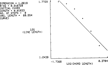
With this discrepancy in mind I looked in more detail at the Shelberg (1982) paper.  While Mandlebot’s Science article simply quotes Richardson’s data, Shelberg’s shows graphs of their results using the example of Kodiak Island in Alaska (a particularly intricate coastline!) with a 1653 point digitisation.

Scatterplot for Kodiak Island (Figure 5 from Shelberg et al., 1982)

The actual points are (in Shelberg et al’s words) “rainbow” shaped, and do not perfectly fit the line.  Following a slightly handwaving argument, the authors decide to effectively ignore the smaller scale data points, leading to a reduced range (recomputed, but effectively the right-hand side of the above graph), which, like the Welsh coast data, looks closer to a straight line … but of course any smooth curve, if looked at closely enough, ends up nearly straight.

I did wonder whether perhaps this deviation of coastlines from ‘pure’ fractal is commonly accepted, but on the Wolfram page for Coastline Paradix, it still says:

“a coastline is an example of a fractal, and plotting the length of the ruler versus the measured length of the coastline on a log-log plot gives a straight line, the slope of which is the fractal dimension of the coastline”

It is clear that the early authors were not intending to ‘massage’ their data, just that they came with a preconceived notion that the coastline will be fractal and assume that deviations are in some way errors, deviations, or noise.  Having removed the problematic data, the assumption is ‘verified’ deepening the folklore of the discipline

Similar self-confirming academic folklore is common. Indeed the same kind of graph with a ‘fitted’ line is common throughout the web self-similarity literature and, in HCI, Fitts’ Law leads to very similar misconceptions.

As with all folklore, these academic myths are based on truth: in this case coasts do get more wiggly as one looks in more detail, fractals (or at least fractal-like) shapes do occur in nature, and power laws do arise in many circumstances – just not everywhere and not perfectly.

Power laws are a good meme, but the world does not always comply!

  1. B. B. Mandelbrot (1967). How long is the coast of Britain? Statistical self-similarity and fractional dimensionScience: 156:636-638.[back]
  2. Richardson, L. F. (1961), “The Problem of Contiquity,” General Systems Yearbook, Vol. 6, pp. 139-187.[back]
  3. The precise fractal dimension of the Koch Snowflake is  log 4 / log 3.  See the Wikipedia page for a derivation.[back]
  4. Mark C. Shelberg,Harold Moellering and Nina Lam (1982). Measuring the Fractal Dimensions of Empirical Cartographic Curves, Defense Mapping Agency Aerospace Center St Louis Afs Mo.[back]

training – first walk

As I’ve not walked more than about 5 or 6 miles since I was 18 … I have some training to do 🙂

… and add to this (1) I always wear sandals, so even putting on a pair of walking shoes give me instant blisters and (2)  have become so so nesh1; I’ve got so used to not being uncomfortable and need to train as much to be prepared to go out in all weathers, to get wet, too hot, too cold, and put up with it.

My plan is to walk a short 6 mile-ish walk every other day through the winter and then longer round the island (17 mile) walk once a week, and had I planned to start as soon as I got back to Tiree after being away in September … but I’ve been busy, deadlines, etc.; hardly left the house let alone long walks in last month 🙁

However, today, at last, my first walk.  Just a short 6 mile circuit down to Hynish and back.  I think that will be my standard short walk as it cuts along the sea all the way, and is not busy with cars (well this is Tiree no road is that busy!).

I’m planning also to experiment using a digital recorder while walking, so the time walking is not ‘wasted’ (hmm, is there a worker-holic tendency in there somewhere?), but today just a stroll by the sea.

When I walk next year I will only need to average 17 miles a day, so fairly relaxed, more the fact of doing that day on day that needs a bit of practice.

  1. Nesh is a lovely dialect world that means soft, not hardy.  The online dictionaries all relate it particularly to cold, although the etymology in the thefreedictionary definiiton is broad “Old English hnesce; related to Gothic hnasqus tender, soft; of obscure origin”.  [back]

measuring it out

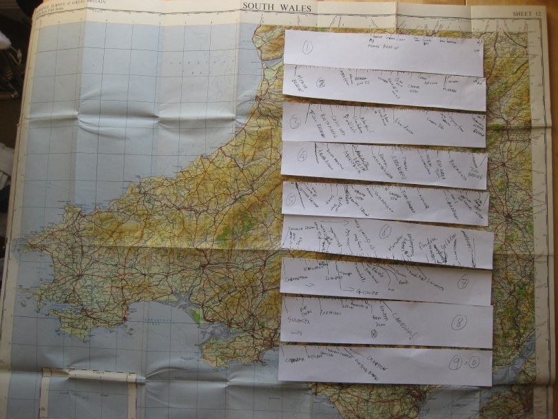
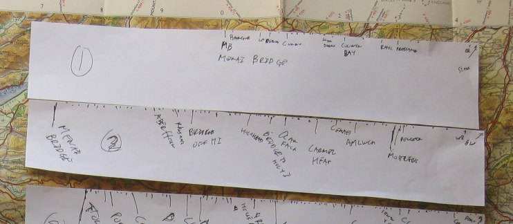
I’m going to put up a page with the rough itinerary, but need to estimate approximately how long it will take to get to each part of the coast.  The Coast Path web site has downloadable brochures for each segment of the path, which give the length of each part.  However, (i) some of these are a little vague, and (ii) the brochures are long and thin so hard to print out to read.   I will address these sometime, but for now, simply traced round the coastline from a 1:625,000 road map1.

It took a while, but I did it while listening to Stef Lewandowski and Lucy Conway from EiggBox on  AmbITion Scotland webcast from Shetland, which was great.

I found it fascinating how long, and how short, some sections were.  The entire north coast from near Chester to the Menai Bridge was only just over half a paper strip long, whereas going round Anglesey, which doesn’t look that far, was nearly whole strip (one strip approx. 120 miles or 7 days walking).  This is a combination of the fact that circumferences are bigger than you think (recall pi x diameter) and the fact that Anglesey has a ‘rougher’ outline (more coves and headlands) than along the north coast.

It will be interesting when I add up the lengths to see how they compare with the official 870 miles of coast2, tracing on a map rounds off all the little bumps and bends, so I’ll get some idea of just how fractal the Welsh coast is!

  1. Not the map in the photo; that is an old quarter inch OS map; it just looked prettier than the road map.[back]
  2. The cost is 870 miles, the 1000 mile total also includes 170 miles of Offa’s Dyke up the Welsh-English border.[back]

Walking Wales – first blog

The post on my personal website announcing the walk: “Walking Wales” (21/9/2012). You may recognise some of the text has been borrowed for this site!

Since then I have made some progress … Facebook and Twitter set up and now this web site is starting to shape up too!

Walking Wales

As some of you already know, next year I will be walking all around Wales: from May to July covering just over 1000 miles in total.

Earlier this year the Welsh Government announced the opening of the Wales Coastal Path a new long distance footpath around the whole coast of Wales. There were several existing long distance paths covering parts of the coastline, as well as numerous stretches of public footpaths at or near the coast. However, these have now been linked, mapped and waymarked creating for the first time, a continuous single route. In addition, the existing Offa’s Dyke long distance path cuts very closely along the Welsh–English border, so that it is possible to make a complete circuit of Wales on the two paths combined.

As soon as I heard the announcement, I knew it was something I had to do, and gradually, as I discussed it with more and more people, the idea has become solid.

This will not be the first complete periplus along these paths; this summer there have been at least two sponsored walkers taking on the route. However, I will be doing the walk with a technology focus, which will, I believe, be unique.

The walk has four main aspects:

personal — I am Welsh, was born and brought up in Cardiff, but have not lived in Wales for over 30 years. The walk will be a form of homecoming, reconnecting with the land and its people that I have been away from for so long. The act of encircling can symbolically ‘encompass’ a thing, as if knowing the periphery one knows the whole. Of course life is not like this, the edge is just that, not the core, not the heart. As a long term ex-pat, a foreigner in my own land, maybe all I can hope to do is scratch the surface, nibble at the edges. However, also I always feel most comfortable as an outsider, as one at the margins, so in some ways I am going to the places where I most feel at home. I will blog, audio blog, tweet and generally share this experience to the extent the tenuous mobile signal allows, but also looking forward to periods of solitude between sea and mountain.

practical — As I walk I will be looking at the IT experience of the walker and also discuss with local communities the IT needs and problems for those at the edges, at the margins. Not least will be issues due to the paucity of network access both patchy mobile signal whilst walking and low-capacity ‘broadband’ at the limits of wind-beaten copper telephone wires — none of the mega-capacity fibre optic of the cities. This will not simply be fact-finding, but actively building prototypes and solutions, both myself (in evenings and ‘days off’) and with others who are part of the project remotely or joining me for legs of the journey1. Geolocation and mobile based applications will be a core part of this, particularly for the walkers experience, but local community needs likely to be far more diverse.

philosophical — Mixed with personal reflections will be an exploration of the meanings of place, of path, of walking, of nomadicity and of locality. Aristotle’s school of philosophy was called the Peripatetic School because discussion took place while walking; over two thousand years later Wordsworth’s poetry was nearly all composed while walking; and for time immemorial routes of pilgrimage have been a focus of both spiritual service and personal enlightenment. This will build on some of my own previous writings in particular past keynotes2 on human understanding of space, and also wider literature such as Rebecca Solnit’s wonderful “Wanderlust“.  This reflection will inform the personal blogging, and after I finish I will edit this into a book or account of the journey.

research3 — the practical outcomes will intersect with various personal research interests including social empowerment, interaction design and algorithmics4.  For the walker’s experience, I will be effectively doing a form of action research!.  This will certainly include how to incorporate local maps (such as tourists town plans) effectively into more large-scale experiences, how ‘crowdsourced’ route knowledge can augment more formal digital and paper resources, data synchonisation to deal with disconnection, and data integration between diverse sources.  In addition I am offering myself as a living lab so that others can use my trip as a place to try out their own sensors and instrumentation5, information systems, content authoring, ethnographic practices, community workshops, etc.  This may involve simply asking me to use things, coming for a single meeting or day, or joining me for parts of the walk.

If any of this interests you, do get in touch.  As well as research collaborations (living lab or supporting direct IT goals) any help in managing logistics, PR, or finding sources of funding/sponsorship for basic costs, most welcome.

I’ll get a dedicated website, Facebook page, twitter account, and charity sponsorship set up soon … watch this space!

  1. Coding whilst walking is something I have thought about (but not done!) for many years, but definitely inspired more recently by Nick the amazing cycling programmer who came to the Spring Tiree Tech Wave.[back]
  2. Welsh Mathematician Walks in Cyberspace“, and “Paths and Patches: patterns of geognosy and gnosis“.[back]
  3. I tried to think of a word beginning with ‘p’ for research, but failed![back]
  4. As I tagged this post I found I was using nearly all my my most common tags — I hadn’t realised quite how much this project cuts across so many areas of interest.[back]
  5. But with the “no blood rule”: if I get sensor sores, the sensors go in the bin 😉 [back]