
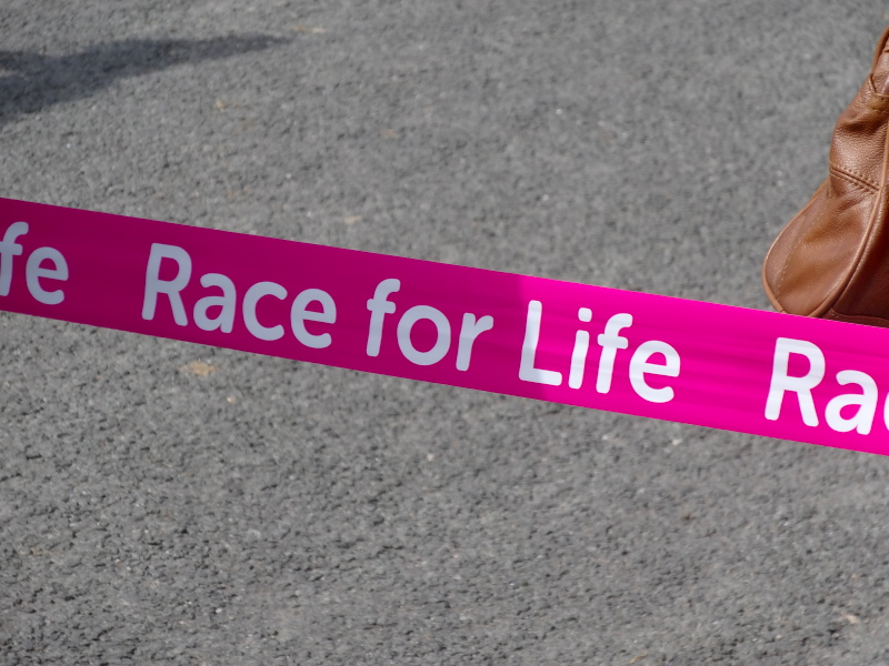
 Paul drove me into Caernarfon and he and his children waved me on my way, sandwiches and banana to sustain me. Our route into Caernarfon had been interrupted by closed roads as today was the Caernarfon Race for Life. The route of the run lay along the same riverside road as the Coast Path, and as I passed the race end point, the first few runners were crossing the line. Then, for the next mile or two, I was walking against a tide of pink: pink t-shirts, pink tutus, pink fairy wings on adults, children and dogs, pink ribbons, pink rabbit ears and even pink hula skirts. One girl had a black t-shirt with ‘This is for you, Nan’.
The runners become walkers, and the fast walkers slow walkers, until eventually the tail-end marshal passes, behind four women who had been space-hopping their way round; two had found it too much and were carrying their space hoppers, but the other two were still bouncing slowly along.
Heart Radio were packing up sound equipment where they had been playing music to encourage the runners, and the first aid car was preparing to drive off. It was wonderful to see so many women and girls of all ages working together for a good cause and so many supporting them from the sidelines.
The road mainly follows lanes and roads, except where it meanders a little to go round the end of an estuary. I follow a signposted path that shrinks from green lane to narrow track and eventually over a bridge and onto a dyke. There was no sign, so I turned left along the dyke and eventually, through a few parts reached the road again. It was only some time later that I realised the route could not be correct and I should have turned right onto the dyke. At leisure I later looked at the 25000 OS map and it is ‘obvious’ which way to go on that, if not from the Coast Path map or (lack of) signage. Whilst gaining me some soggy feet, it did cut off a mile or so of walking, so not an ultimate disaster, but it did cost me the only actual moments beside the sea in the day.
 For maybe 10 miles, maybe more, the Coast Path runs along the main Caernarfon–Nefyn road, sometimes in separate footpath beside the road, sometimes taking the old path of the road through the villages along the way. I have often found the discipline of walking places you would not walk if it were a holiday in some ways giving me insights that the obvious pretty holiday destinations have not. There were a few interesting points, a glass and bent steel garden mermaid, Beuno’s Well (not as mystical as the one amongst the moorland on Anglesey), and the small solid abandoned building of the ‘Enderby, Stoney and Stanton Granite Co.‘ (I assume an old quarry office). However, to be honest, this is just a road march, but a quick way to eat up miles.
This slow walk really gives one a sense of distance as The Rivals, the high hills/small mountains that separate Llŷn from the rest of Caernarfonshire approach. Indeed it was almost a surprise when I realised that some of the hills that had been ahead for so long were actually beside me.
Eventually, the path turns in towards Trefor, where it skirts the village, drops to the small working harbour and goes round the headland, before coming round to the south-west side of the village ready to ascend the hill pass. The hill above Trefor is heavily quarried and the reason for the current village. The old engine houses and maybe quarry offices sit Tolkien-like high on the hillside as if they were a castle with keep and outer walled courtyard, all suspended precipitously above the crumbling slate slopes. As you look up towards it, you pass the site of the old hotel (there is now nowhere to stay in Trefor), and then a private club, men drinking outside, that appears to be the old working mens’ club from the days of the quarry.
It will be my first proper ascent since Offa’s Dyke, but one I need to do quickly as it is already six o’clock. Initially you go up a small lane, so narrow that when an old Ford Escort comes up the lane behind me it has to stop and I squeeze back round it before it can continue. At the top, as the road turns sharp left, the (for once) well marked coastal path sign sends you straight onwards, directly up the hill, where barely 50 yards on, the farmer has blocked the path with a small fence of wooden pallet and metal fencing all tied together with baler twine.
At first I think that maybe the baler twine loops off in some way to swing the pallet awkwardly open, but on closer examination the only way to get through would be to cut the baler twine. I have no knife with me to cut my way through, and the blockage is too rickety to climb without pulling down the fence posts on either side. Even though the farmer had clearly blocked the path deliberately, I couldn’t bring myself to deliberately cause this damage, albeit justified to keep the path open. Maybe if I had come down the pass I would have forced my way through no matter the damage.
Another public footpath leads off directly to the left along a green lane, but it too is blocked another 50 yards on with barbed wire. So reluctantly I backtrack and go round the hills on the road. If it had been a shorter day (I had already walked nearly 20 miles before encountering this), and less late, I would have persevered, but if it was blocked here I realised it might well be blocked again later and I foresaw myself being stuck on the hillside as dusk came down.
As I rejoined the main road barely two miles from where I left it and skirted the hills, I felt doubly cheated, as Paul had suggested an alternative path to go along this road and then branch off up Tre’r Ceiri fort, round Yr Eifl and rejoin the Coast Path above Nant Gwrtheyrn, the hidden valley. I passed the end of the path up to Tre’r Ceiri, but it was by now far too late to attempt this. Instead, even when the road rejoined the path I ignored the meandering of the Coast Path signs either side of the road and simply marched on, getting to Caeau Capel Hotel in Nefyn just in time to eat.
However, the road detour did open a glimpse into a local story, which I’ll never fully know.
Just as the road approached its highest point skirting Yr Eifl, a man appeared coming down over the high spot with a dark holdall in his hand. I thought again, just as I had earlier in the day when I met someone not far out of Caernarfon, that there are clearly people on the road for whom walking is a necessity, not a choice.
When I came into the next village, [{Llithfaen}}, I paused for a moment to get some water and phone Caeau Capel to say I was on my way. A few moments later I passed a group of women and men on the roadside looking down the road from which I was approaching. "Have you seen a young lad", one of the ladies asks. I think for a moment, as a boy may have passed me while I was rooting in my rucksack; as I pause, she says, "with a rucksack", "no a carry bag", another pipes in. "Yes, I saw him back on the road", I reply. They quiz me further, how far back? ten minutes? half an hour?
Various thoughts go through my mind. Is this a husband or son who has had an argument and gone off and they are worried? Was he going on a known journey, and they were checking on progress? They did not seem worried, however, and seemed uncertain as to which direction he was going.
So, when eventually they were satisfied that they understood where he was and which direction he was going, I ask "is he a relative?", but, "no just someone we’re interested in", they say.
Various other thoughts flash through my mind, maybe an internecine feud and the young man is fleeing retribution for an insult or crime. However, they all seem in a good mood, so more likely simple benevolent interest … but deep into the margins you can never tell.