
sandal walking again, wild ponies and a floating seal, Hebridean havoc and the first feminist, spray drift and the true path
25th June 2013
miles completed: 765
miles to go: 303
 On the Strumble Shuttle, the bus from St Davids to Abereiddy, is the same elderly lady from the day before. She did her full distance as planned, Trefin to Whitesands Bay, eleven miles. Unfortunately on the part of the path she had been on they had been strimming the grass and she had been suffering with hay fever all night. Today she is planning to walk to Goodwick, I don’t recall where from, but I did tell her about the Fairyland teas!
At the Abereiddy car park, another group of schoolchildren get ready for coasteering and are being given instructions on how to put on a wetsuit without getting stuck. I don’t wait to see if they manage it.
 It is another day of relatively easy walking. My feet had got very sore towards the end of the previous day, so today I am wearing sandals again. In some ways this is not the best footwear as the path is quite stony in places, and the points of sharp stones can hurt through the thin soles of the sandals. However, I have none of the pressure soreness from wearing boots, and my feet have a chance to ‘air’. Indeed, the day before, I had to peel my inner socks off as if I were pulling off a layer of skin … and don’t think about the smell :-(.
I don’t recall anything of note between Abereiddy and Whitesands, except playing coast path ‘leapfrog’ for a while with a Canadian lady, who was walking nearly the same speed, but very slightly more slowly than me, so that I would get ahead, but when I stopped to take photographs, or chat to someone, she would pass by.
On this stretch I got my first glimpse of St Davids, indeed the only glimpse of St Davids, from the coastal path. The dell in which it is set was called ‘Vallis Rosina‘, the valley of the little marsh. St David was an ascetic, so a monastery in a marsh would probably have suited him, but above all, as has been evident from going round the coast, it is not easy to spot from the sea.
However, a thousand years ago, just as today, military intelligence serves where direct observation fails, and clearly the Vikings did, at various times, work out where it was to come to burn, loot and kill. The last attack was by the ‘Norsemen of the Isles‘1. These will have been from the Hebrides, which remained Norse territory, the ‘Kingdom of the Isles‘, until the 13th century … so, a link to Tiree.
The last promontory before Whitesands Bay is St Davids Head. This has been increasingly a land of ponies, who graze the moor-like areas around the clifftops and the hills inland. On St David’s Head itself there is a herd of about 20 grazing together. As in sheep country, it can be hard to tell the difference between person tracks and pony tracks and I quickly lost track of the ‘real’ Coast Path, but it doesn’t really matter so long as one keeps reasonably close to the sea and heads out along the headland.
The night before, as I drove back to St Davids, there was an interview with John Humphrys (that is JH being interviewed for once). He said that as a political journalist he wasn’t sure whether ‘truth’ was a useful concept. He tried to help people see the facts so that they could make up their minds, their own ‘truth’, and yet as he expressed this doubt about absolute truth, he could not avoid repeatedly using the word.
I think he was thinking of things like "the last Labour government was spendthrift" as opposed to "the last Labour government‘s annual deficit until the banking crisis was less than 40 billion pounds as opposed to the current government’s 120 billion"; the former a possible ‘truth’ if you decide to believe it, the latter ‘facts’.
So, is there a ‘true’ Coast Path? There is clearly an ‘official’ one, but is it the ‘right’ one?
 In fact, I am sure I wasn’t on the official one, nor even the right one, as the path I was following showed that it definitely was a pony track and petered out. However, I was able to find a different person (or maybe pony) track that led to the high point of St David’s Head, and then round the back of it where I found a cromlech (or maybe dolmen, I’m not sure of the distinction), a huge flat stone propped up by another enormous stone, like a giant rabbit snare: push the supporting stone out of the way and ten tons of rock crashes down on you, instant rabbit pancake.
Whitesands Bay itself is wide and open to the Celtic Sea. This was a calm day, so while there were plenty of surfboards on the sea, they were mainly paddling around. However, I can imagine that the surf shops in St Davids are justified, as when the wind and waves come off the Atlantic, there is nothing between America and the beach here to stop them.
It is still out of main season, so the large car park is well used but not overfull, and the beach also has plenty of people, but does not seem at all crowded. However, critically, the beach is busy enough to merit a substantial beach café! So with a ‘Surf Burger’ in my hand I sit to eat.
A man approaches me, looks at my t-shirt (the Tiree 10K one) and says, "does that say ‘Tiree‘". It turns out his wife is the mother of the Tiree librarian. They tell me about their house set on a hillside amongst a forest in the Teifi Valley. The slope of the land means their conservatory looks straight into the treetops. "It is like living in a treehouse," he says.
There is a path leading up the back of the beach, so I take that, unsure whether there will be other ways up, as the far side of the beach backs into a rocky cliff. However, there are steps up about a third of the way along the beach, so it would have been possible to get some sand between my toes.
Soon after Whitesands Bay, you turn Point St John and, instead of the open ocean to the right, there is the Sound of Ramsey, with Ramsey Island beyond. The island has steep cliffs, just like the mainland, but then, over most of the island, a plateau of flat fields, at a height, I guess, of about 200 feet. Two hills rise up from the plain towards the centre and north of the island, but towards the south, it is as if the island has been in a car crash: the land is concertinaed into a series of small hills, like crumpled paper.
The Welsh name is Ynys Dewi, David’s Island, David not Ramsey; I’m not sure of the linguistic, national or religious politics in that.
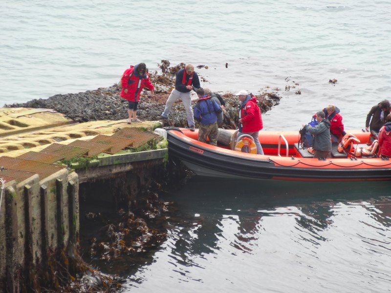 The inlet of St Justinian is home to the St Davids Lifeboat Station, and also the point where boats ply back and forth, taking day-trippers across to Ramsey Island. One is landing as I pass, a rib, and the passengers step gingerly from the bobbing craft to the steps beside the lifeboat slipway.
On the path is a small yellow plastic square, with a metal plug, about the diameter of a tubular handrail. It was flat to the ground, so only noticeable if you look down at the right moment. I wonder if it is a plug covering a hole to insert a metal tube in, but then I cant think why you’d want to have a vertical metal rod and anyway I can’t prise it open; another one for my list of mysteries of the way.
Further on people sit on the cliff watching a grey seal floating in the water, and further again a couple sit together looking out to sea, while a sea gull stands on a rock a few feet behind, looking over their shoulder.
This is a busier part of the path, I see some people (as opposed to nobody) going my way and some in the other direction. Most are couples, but some solo walkers, like myself, and a very small number of bigger groups. Most are retirees or of that age, but in this section there are also an increasing number of younger people including the occasional family.
One couple warns me of crop spraying ahead, although the wind is coming from the sea, so should blow most of the spray drift away from me. I see the sprayer, which is a dedicated machine, not simply a tractor-towed spray, but it is moving between fields, so I am not showered.
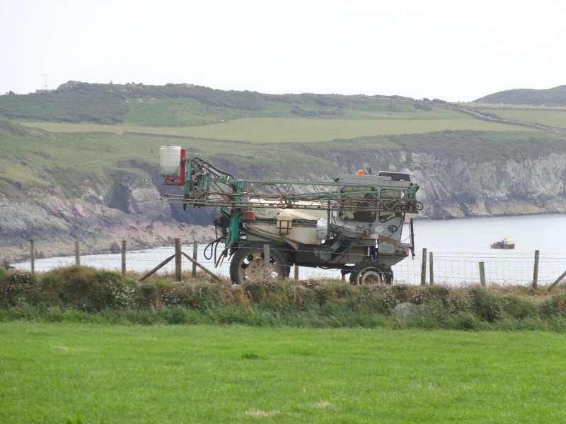 My first job was mathematical and computational modelling of agricultural sprays in the ‘Spray Physics Group’ at the National Institute of Agricultural Engineering. Spray drift was one of the great problems then, and is still today. The drift is mainly from the very smallest drops, tens of microns across, a tiny volume of liquid, but a large number of individual drops. At these very small sizes, gravity is virtually impotent and the tiniest air currents take them anywhere.
Some of the work in the area was about trying to make sprays with more uniform drop sizes (usually in the 100s of microns, say a third to a fifth of a millimetre), so with fewer tiny drops to blow away. One of the techniques included spinning a disk very fast, like a supercharged record player, then dribbling the spray on the disk, flinging it in all directions. Unlikely though it sounds, it actually produces very good spray!
My own work was more focused on electrostatically charged sprays. That is, you put a charge on the spray using a high voltage electrode and then the spray drops become attracted to any earthed object, including the plant leaves. We were mainly dealing with water-based sprays, but ICI had developed oil-based electrostatic sprays where the electric field tore the fluid apart, making the spray as well as helping it get to the crops. We did debunk some of their more grandiose claims, but still it was an interesting system. Less good was the way they were marketing and testing the early commercial versions in Africa.
There are good agricultural reasons to use oil-based sprays in a hot climate: water-based sprays can evaporate away before they even hit the crop. And there are also good business reasons; once you have bought an ICI electrostatic sprayer, you have to get all the special fluids from them! In addition, health and safety regimes are less strict, which is ‘useful’ for a new product. Indeed the picture used in a lot of their marketing materials depicted an African labourer walking through a field of maize with a hand-held unit held on a pole at head height. The man wore no protective clothing. The literature claimed that the spray, being electrostatically charged, would head straight for the crops. However, the truth is it will head for any earthed object, including the labourer’s head.
I have no idea whether ICI‘s system or the systems being developed at our unit have ever been widely used.
 The last inlet before Caerfai Bay, where my van is camped, is Porth Clais, a narrow but deep inlet, a natural harbour with a substantial breakwater added. There are, of course, the obligatory lime kilns, but a lot of them, two either side of the harbour, so maybe this was one of the major ports for the lime for the area.
There is also a café/kiosk, but I am almost at the end of my journey for the day and continue (passing tea!).
Finally, the path passes close to the church of St Non, David‘s mother. The story is that she was being pursued by David‘s father, a local king (although I don’t know why she was running away), and the church is where she gave birth. She obviously continued to have marital problems, as she later seemed to spend her life founding religious houses, rather than playing the dutiful wife – early ‘women’s lib‘?
As the path leads down the west side of Caerfai Bay there is a flat-topped stone beside the path with a Celtic cross incised upon it; there is nothing marked on the map, so one to try to find out about later.
I exit the path on a series of wooden steps, but there is nothing on the footpath sign to say this leads to the road. In general the Pembroke footpath signs are relatively good at telling you what is off path, so maybe they were just having a bad day.
- See p.5, ‘St Davids Bishop’s Palace‘, CADW, 1991.[back]