
"It’s hard, very hard."
I was slowly nursing a half pint at the Webley Arms, between St Dogmaels and Poppit Sands, knowing that when it was finished I had to go back into the rain with no more places to stop until I got to Newport, when I overheard these words.
I had started walking late as I’d moved the van from Aberaeron to Newport and then had to wait for the bus. The bus routes form ‘watersheds’ along the coast and effectively make Fishguard to Cardigan a separate section of the coast, with an hourly bus service and no changes.
By the time I had parked the van, paid the site and walked the half mile up the road to the centre of Newport, I had just missed one bus so had time for a breakfast at the Fronlas Café before getting the noon bus. So it was nearly 1pm by the time I was on my way out of Cardigan.
 The coast route pretty much misses Cardigan, although it is only a five-minute walk into the town centre where I’d caught the bus to Aberaeron the previous day. The route does take you under the town walls and to the quayside, with its statue of an otter. Otters have been reintroduced into the Teifi, and I notice signs the previous day warning boat owners to keep away from the shores to protect the otters‘ habitat.
In one of the maps at Lampeter there was a remark on one river that it was the last place that an otter, or maybe it was a beaver, was seen in Wales, and it may even have been the Teifi.
The otter statue is close to the footbridge over the river that runs parallel to the old stone bridge, still used by traffic, but effectively single file for modern vehicles.
My OS map shows the Ceredigion Coast Path following the Teifi very closely, but the Wales Coast Path zig-zags through lanes and fields a short way from the shore. Maybe there have been access problems on the old route, or maybe the Wales Coast Path planners thought the shore route too easy.
 Both routes take you to St Dogmaels, where you can see the ruins of a Norman Abbey, itself built on the set of a fifth century monastery. While Cardigan, a mile away, was the administrative and military centre with its castle, St Dogmaels was the religious centre of the area.
Beyond St Dogmaels, the path follows along beside the river passing the ‘Answer Stone‘ or ‘Blessing Stone‘, believed to be the capstone of a dolmen, where fishing boats were blessed by the Abbot of St Dogmaels.
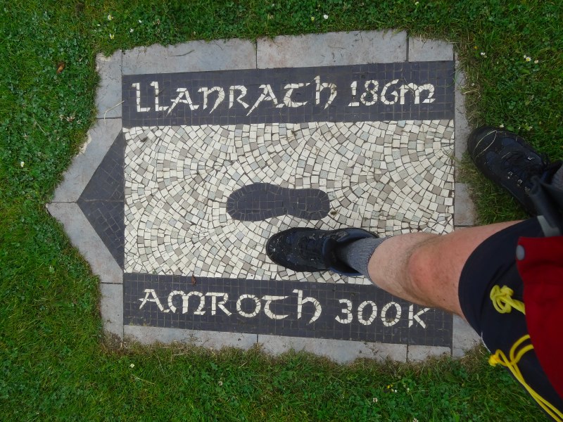
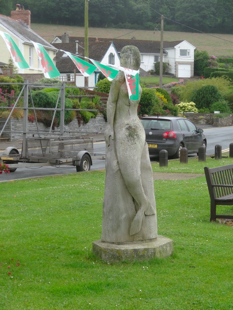
Also at St Dogmaels, just past a flag-draped mermaid, is the plaque and plinth declaring the official start of the Pembroke Coast Path. The plaque has a footstep marked on it, and I place my booted foot beside it.
 And it had started to rain, not hard but slow dampening drizzle.
Getting increasingly damp, I decided to take a half pint at the Webley Arms, which I thought the last point of refreshment before Newport, although I later realised there is a café, maybe half a mile further, before the road climbs away from the river and sea.
When I came in, the bar was empty, but then three young men came in and this was when I overheard the words. He was talking abut the problems of having recently moved to the area, and his colleagues sympathised, and also talked about winter employment, and going away for the winter to do seasonal work in ski resorts.
It seems transhumance is not uncommon in West Wales, both the ‘summer by the sea and winter inland’ of the retirees in New Quay and this seasonal search for employment. Four thousand years previously, Neolithic tribes would have moved camps depending on when different foodstuffs became available, and the seasonal movements of the animals they hunted, and in West Wales not so much has changed.
The landlord tells me later that it can be very hard for incomers, unless they have some personal connection such as marrying a local. There is no underlying animosity or intention to exclude, but communities are tight and existing relationships strong. In addition, it is hard for those used to the bustle of the city, the winters are very quiet and even the summers depend critically on weather.
 Furthermore, the natural language of the area is Welsh. When we talked about experiences in Anglesey, Rosie complained of the rudeness when at a bar, two people she had been talking to in English would suddenly say a few words to each other in Welsh. Because she knew they could speak English, it felt impolite to be excluded. My guess is they were not even aware of the language switch, just like you change the vocabulary you use when switching between talking to a child and to its parent.
That morning I’d been asking the lady at the reception at the campsite whether there was a hose fill point for the campervan. She said there wasn’t, but maybe there was something about.
"I’ll ask one of the boys," she said, referring to the ground staff.
Going out of the building she saw one in the distance, and instantly called out in Welsh.
I think it is hard for English speakers to realise that while everyone *can* speak English, and indeed will do so without apparent effort, it is more like going to Spain or Italy to live. You can get away with speaking English and most people will understand and respond, but when rapid communication is needed, you should not expect to be able to understand what is said. I recall many evenings in Italy with groups of Italians, who would start the evening talking in English for my benefit, but would then lapse into Italian as they got tired, after a while notice, apologise, maybe have a short English conversation, before once more lapsing into their native tongue.
The landlord also talked about jobs, or rather the lack of them.
I have seen some Eastern European staff at cafés and hotels, but far fewer than, say, in London. I guess the very fact that they are here would be seen as some a sign of British fecklessness; why aren’t all those unemployed out there taking these jobs? Of course the truth is that they are no more so than the Austrian or Swiss youth, when young folk like those in the bar go abroad for the winter, or the Spanish or Greek youth, when Mediterranean resorts fill with British tour guides and bartenders seeking summer sun and fun.
Transhumance is fine for the retired or young couples, but not the best basis for starting a family. I spent a significant portion of my own children’s young years working away from home, although that was more about family choices of where to live and I was fortunate in mostly only having to be away for part of the week. For many professional couples the need to maintain two careers can involve travelling across countries or even continents.
 The route past Poppit Sands leads along small roads or paths beside them, past the final café and signs warning ‘the aliens have landed’ (Himalayan Balsam), until eventually it comes to an end and there is a stark sign warning you that you are about to enter a ‘remote, rugged and challenging stretch’ of the Pembrokeshire Coast Path, 13 miles with ‘numerous very steep hills’ and few exit points.
Although the landlord of the Webley Arms had also warned me that this was the hardest part of the Pembroke path, I had seen signs like this on the Ceredigion Coast Path, so was not terribly daunted,
This is not Ceredigion.
I was about to start what will be the most arduous day of the walk so far (and I hope the whole walk).
Later that day I spoke to Paul, a local who recalled the creation of the Pembrokeshire Coast Path, I think 20–25 years ago. They drove a small bulldozer along it, he recalls. It would have once been wide and flat like the stretches of the Ceredigion path that had equal dire warnings. But 20 years of feet, rain and erosion have taken their toll. The path itself is heavily rutted, in places down to around 10 inches wide, but an equal depth. You have to place your feet one behind the other, like walking a tight rope, and at each step risk catching one foot against the other or against the sides of the foot rut.
There are glorious views, and, happily, soon after I started the path, the mists and drizzle passed and so most of the afternoon was spent in sunshine, so, in a way, I had it as good as it could be. However, looking up to the view always led to a trip on a stone, or tussock, so was better reserved for occasional poses between staring several steps ahead attempting, but not always avoiding ‘trip hazards’.
The fine dusty soil had become oil-slick-like in the light drizzle, but happily dried quickly where the sun could get at it. I can’t imagine what it would be like in real rain.
 Beside the narrow rutted path, the grass and bracken had encroached, and varied between knee and waist height. Straight after the drizzle, it was still wet and quickly soaked my bare legs, which then drained down into soggy socks and eventually water-filled boots. I squelched on each step and water squeezed out of the seams as if I had a small spring with running water emerging from between my toes.
And of course the high grass made it hard to see the stones, tussocks and occasional rabbit holes, meaning that even lifting my feet, tramping-style, at each step, I would still trip occasionally.
As well as being hard work, tripping is not pleasant when you are aware of 300-foot cliffs close to the side.
Around Scout campfires we would sometimes sing (to the tune of the Battle Hymn of the Republic)
He jumped from twenty thousand feet and forgot to pull the cord (x3)
and he ain’t gonna jump no more
refrain: Glory, Glory Alleluia (x3), and he ain’t gonna jump no more
They scraped him off the pavement like a lump of strawberry jam (x3)
and he ain’t gonna jump no more
refrain
They packed him in a matchbox and they sent him home to mum (x3)
and he ain’t gonna jump no more
refrain
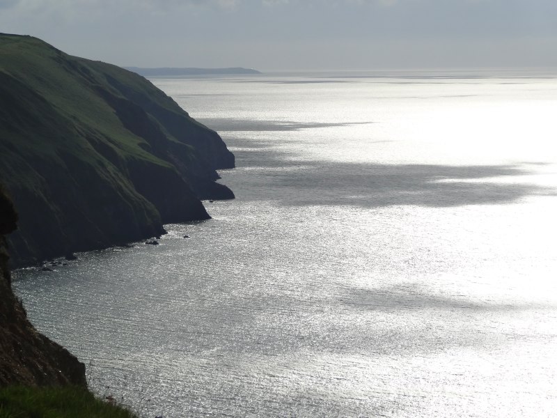
At first I had thought that these cliffs were of the scratched arms, bruises and broken limb variety rather than a strawberry jam class as the grass and bracken seemed to slope away, albeit steeply at 75é80 degrees to the horizontal. However, looking forward and back I realised that this steep grassy slope ended between 10 and thirty foot below at a vertical drop down a rocky cliff.
Paul, who told me about the mini-bulldozer, said that he always told walkers that they had not had any fatalities from the cliffs, "it is the farmers you have to worry about". Walkers who want to give up on the cliff path have no official exit, so they climb and break down fences, understandably angering the farmers, although the bodies of tourists full of shotgun pellets, Paul admitted, was hyperbole.
Certainly the pig-netting fences between walker and fields were topped with two strands of barbed wire; I have never seen this elsewhere. I was uncertain whether this was to keep the walkers on the cliff side of the fence, where they belonged, or as an extra mechanism to keep the cattle and sheep inland, since the cliffs are too dangerous for any animal, barring walkers.
About halfway is last of the exit points at Cwm Trewyddel, where the village of Moylgrove nestles about a mile inland.
Another sign threatens more challenging walking for the final, and totally inescapable, seven miles.
I press on.
 I said the soil was largely sun dried. There were exceptions, where the grass was too long for the heat to penetrate, or when shadowed by the land.
There was one such steep slope, that began as steep step-like footmarks in sloping grass, but degenerated into a slithery mud slide.
I recall the old maths puzzle:
A snail climbs up a wall two feet a day, then as it sleeps overnight slips back one foot. How many days will it take to climb a six-foot wall?1
This slope is just like that. Eventually, on the steepest section, I am virtually on hands and knees, holding on to the grass at the side, but trying to avoid putting my hands on the gorse seedlings spaced sporadically to catch the unwary.
And this was simply after drizzle.
A short while after Cwm Trewyddel the path becomes wider, more grassy, and I think it will be easier going now. The reason is that there are ponies grazing on the cliff side of the fence in this area, which is also more open with a slightly less steep slope down to the sea.
However, the hopes of an easy run back to Newport are soon dashed, as the area with the ponies are is left behind and the path once more narrows to a single, rutted, overgrown track.
In high school we used to have ‘comprehension’ lessons in English. We had a small book with passages of maybe half a page, and then a series of questions to answer about the passage, some factual, some more interpretative. One passage was Edmund Hillary‘s account of the last part of the ascent of Everest. He and Sherpa Tensing are making their way up the ridge and again and again a tantalising peak ahead makes them think that at last they will be at the summit, but again and again, as they reach the peak, they see the sun-sharp, snow ridge still stretch away ahead to another, higher peak.
 Since rounding Cemaes Head, it seemed a lifetime ago, but barely four hours, a large peaked headland had dominated the coast; looking now on the map, the peak is Foel Goch. Throughout the afternoon it slowly, too slowly, got closer, until eventually I was on the final stretch. By this time the path had again degenerated, and I had reached that "just wish I was at the end" point, but I was nearly there, and the time was not too bad, I might get to Newport earlier than I’d expected, and certainly in plenty of time for a meal at one of the Newport pubs which serve until 9pm.
Looking now at the map, spread out, the lie of the land is obvious, but it was less so looking at a small segment of a folded-over map. I rounded the ‘final’ corner and ahead was another, smaller headland, I rounded that and another appeared. Ahead Dinas Island appeared, and I began to fear that maybe it too, albeit far distant, was yet another headland before Newport. Happily, eventually, Newport town appeared far across the bay, and with great relief I began the slow descent towards Newport Sands.
It was only then that I realised the tension in my body, my breathing was shallow, and I’m sure my heart rate high. In some stretches of the path there may be a short place where one has to step carefully, but here for nearly six hours the ground underfoot had been difficult, threatening to trip one if a foot was placed badly, and there was nearly always a precipitous slope beside.
Now I should say, there is a small element of hyperbole of my own in the account. There have been fatalities along the coastal path, but I think where people have strayed off the path, and as Paul told me, "no one has been killed on the cliffs" in this section (although, I note, he didn’t say "no one has fallen"). And, compared with Alpine passes, or, I am sure, with many other coastal and mountain paths in the UK, this is an afternoon stroll. However, it is an area where you cannot afford to be careless. Maintaining that concentration for six hours is exhausting in itself.
As on other occasions when the going has been tough for various reasons, I think again of Arry *running* the coast path and my admiration of her achievement grows.
As I drop down to Newport Sands there is what appears to be a game of beach rugby in progress. The path heads off the beach itself and cuts across a golf course. I might have been tempted to walk around the beach and rejoin the path the other side of the golf course, but it was late and I was worried I would be too late for food; I had a tin of Heinz sausage and beans in the van, but I felt more solid sustenance was in order.
The landlord of the Webley Arms had told me that I should call in on the Golf Club, as it serves the best beer in Newport and the Coast Path passes within a few hundred yards across the greens, but, alas, time was short.
From Newport Sands to Newport itself is three miles by road, but happily a little closer by foot up one side of the estuary, then down the other. At one point I think I can hear the sound of drumming, maybe some kind of African or native American rhythms, but then decide it must be distorted echoes of distant rock music from a parked car.
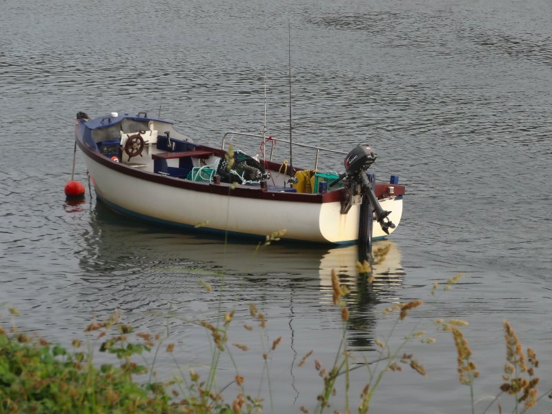 Yay, at last, I see the boats ahead, pass the boat club building (a working place, no public bar or food), and trudge the half mile up the hill to arrive at the Royal Oak with just fifteen minutes to spare before the kitchen closes.
As I order someone calls me by name; I have got used to that: "Alan, what does it say on your back?".
However, this time it is not my rucksack banner, but my t-shirt. I am wearing one of the HCI course t-shirts that I took in order to wear to CHI. On the front is a rather nice logo, but on the back a slightly embarrassing slogan advertising the online course, added by Arunn, who has a marketing background. I usually try to hide the back by wearing a rucksack, but had taken it off and left it at my table.
I explain to the group of three men about the online course and also the walk. I had mentioned Ramblers at one point, and the one who originally called me pointed to another and said, "he’s a rambler".
"No, I’m a walker," he responded.
Clearly there is a whole set of subtleties I’m missing here, does he mean long-distance rather than afternoon walking, or maybe to do with Ramblers as an organisation? I decide best not to dig.
It turns out he has done various long-distance walks including the Pennine Way. He described how he would get lifts:
"I’d be in the bar and say loudly, ‘anyone going to Hebden Bridge tomorrow’, and usually someone would say, ‘yes’ and offer a lift."
I explained that while I was not good at declaring myself so forthrightly, the banner on the rucksack helped as it then prompted other people to ask me about what I was doing.
As we talked the men explained they all came from Moylegrove, the village inland from the last ‘exit point’ of the stretch today. Moylegrove no longer has a shop, post office or pub, so they come to Newport.
They also say I should go back down the path to see the Carreg Coetan Burial Chamber, as this night is Midsummer and there will be twenty naked dancing virgins. This does explain the drumming I heard, but I’m not convinced about the dancing; I think twenty naked virgins will be hard to come upon nowadays, and it is not the nudity that is problematic.
Later as I sit eating my food, the walker (not rambler) comes over and offers me a pint. He tells me how kind people were when he was walking up in the Pennines, how people would not accept anything when they gave him lifts, except maybe a pint. In turn I told him about some of the moments of hospitality and kindness along the way, including the hard day ending at Harlech and the lovely folk at the Lion Hotel.
This day had been a different kind of hard: physically and mentally, yet not so emotionally demanding; but the friendliness and kindness here was equally welcome.
It was only the following morning, as I planned the next day and reworked out mileages, for the first time for a week or more, that I realised that Newport was 704 miles, two-thirds of the way round. The challenging day a fitting point to reach a milestone.
Addendum: The spelling corrector recognises ‘vertiginous’, so it must be in the dictionary, and I hope means what I hoped it would mean when I wrote it, but with no dictionary and no internet to hand as I write, here is my definition:
vertiginous (adj) – the property of engendering vertigo
.
- In case you don’t know this one, the answer is five days, not six. The mathematician might think "it goes up a foot a day in total, so will take six days", but the last day it will just get to the top so not slip back. It is one of those examples used to emphasise that both mathematics and common sense are needed to solve ‘real’ problems … although no snail I’ve seen is really *that* slow.[back]