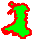
 I started in Cardiff on 18th April 2013, walking East past Newport, then up Offa’s Dyke and the borders, round the new Welsh Coast Path from Chester along the North Wales coast, around Anglesey and Lleyn Peninsula, down the West coast, around Pembroke and then along the South from Carmarthen, round Gower, finally ending up back at Cardiff on 28th July 2013 – my birthday!
I planed to walk for approximately 60 days averaging 17 miles per day, to allow time for writing, talks, and the odd wedding. However, my waking pace was slower than I’d hoped (although exactly what experienced ramblers told me), so ended up with 77 full or part walking days averaging around 15 miles for a complete walking day, but with some very long days (29 miles) and some quite short ones.
Key dates:
The following stages are based on where my bits of paper ran out when I was first measuring up last year, but also start-end at significant points. I’ll probably modify at some stage to correspond to the official WCP sections, or at least mark these.
Cardiff to Severn Bridge - 2013-04-18 to 2013-04-19
distance: 41.7 miles
walking days: , total 0
| Cardiff | 0.0 | 0.0 | 0.0 |
| Pengham, Rumney Bridge | 5.0 | 5.0 | 5.0 |
| Peterstone Wentlooge | 4.0 | 9.0 | 9.0 |
| West Usk Lighthouse | 3.5 | 12.5 | 12.5 |
| Newport Transporter Bridge (West) | 3.5 | 16.0 | 16.0 |
| Newport | 0.6 | 16.6 | 16.6 |
| Nash | 4.1 | 20.7 | 20.7 |
| Goldcliff | 5.5 | 26.2 | 26.2 |
| Redwick | 3.8 | 30.0 | 30.0 |
| Caldicot | 5.4 | 35.4 | 35.4 |
| Severn Bridge | 6.3 | 41.7 | 41.7 |
Severn Bridge to Kington - 2013-04-20 to 2013-04-24
distance: 77.3 miles
walking days: , total 0
| Severn Bridge | 6.3 | 6.3 | 48.0 |
| Chepstow | 2.7 | 9.0 | 50.7 |
| Sedbury Cliffs | 1.8 | 10.8 | 52.5 |
| Chepstow: near bridge | 1.8 | 12.6 | 54.3 |
| Tutshill Folly | 0.2 | 12.8 | 54.5 |
| Brockweir (SO546013) | 5.6 | 18.4 | 60.1 |
| Bigsweir Bridge | 3.1 | 21.5 | 63.2 |
| Redbrook (SO536105) | 3.8 | 25.3 | 67.0 |
| Kymin Naval Temple | 1.5 | 26.8 | 68.5 |
| Monmouth: Monnow Bridge | 2.0 | 28.8 | 70.5 |
| Caggle Street | 12.0 | 40.8 | 82.5 |
| Llangattock LD (SO360201) | 2.0 | 42.8 | 84.5 |
| Pandy (Lancaster Arms) | 2.2 | 45.0 | 86.7 |
| SO307270 Llanthony to Longtown cross-path | 4.8 | 49.8 | 91.5 |
| Hay-on-Wye | 13.0 | 62.8 | 104.5 |
| Newchurch | 6.4 | 69.2 | 110.9 |
| Gladestry | 3.6 | 72.8 | 114.5 |
| Kington | 4.5 | 77.3 | 119.0 |
Stage 3 - Offa's Dyke Mid Wales (more details)
Kington to Llangollen - 2013-05-04 to 2013-05-08
distance: 73.5 miles
walking days: , total 0
| Kington | 0.0 | 0.0 | 119.0 |
| Discoed (SO272651) | 7.2 | 7.2 | 126.2 |
| Knighton | 6.3 | 13.5 | 132.5 |
| Selley (SO264770) | 3.5 | 17.0 | 136.0 |
| B4368 Newcastle | 3.7 | 20.7 | 139.7 |
| Middle Knuck (SO261864) | 3.3 | 24.0 | 143.0 |
| B4368 Montgomery | 7.5 | 31.5 | 150.5 |
| Montgomery | 0.0 | 31.5 | 150.5 |
| Forden | 2.4 | 33.9 | 152.9 |
| Buttington Bridge | 7.3 | 41.2 | 160.2 |
| Pool Quay | 2.3 | 43.5 | 162.5 |
| Llanymynech | 8.0 | 51.5 | 170.5 |
| Porth y Waen | 2.5 | 54.0 | 173.0 |
| Trefonen | 3.5 | 57.5 | 176.5 |
| Chirk | 8.0 | 65.5 | 184.5 |
| Trevor | 5.0 | 70.5 | 189.5 |
| Llangollen | 3.0 | 73.5 | 192.5 |
Llangollen to Prestatyn - 2013-05-10 to 2013-05-11
distance: 36.3 miles
walking days: , total 0
| Llangollen | 0.0 | 0.0 | 192.5 |
| Llandegla | 8.0 | 8.0 | 200.5 |
| Bwlch Penbarras | 7.6 | 15.6 | 208.1 |
| Bodfari | 8.4 | 24.0 | 216.5 |
| Rhuallt | 5.0 | 29.0 | 221.5 |
| Prestatyn | 7.3 | 36.3 | 228.8 |
Chester to Menai Bridge - 2013-05-12 to 2013-05-17
distance: 76.7 miles
walking days: , total 0
| Chester | 0.0 | 0.0 | 228.8 |
| Connah's Quay | 6.5 | 6.5 | 235.3 |
| Prestatyn | 21.2 | 27.7 | 256.5 |
| Rhyl | 3.8 | 31.5 | 260.3 |
| Colwyn Bay | 10.7 | 42.2 | 271.0 |
| Llandudno | 5.7 | 47.9 | 276.7 |
| Conwy | 8.7 | 56.6 | 285.4 |
| Penmaenmawr | 4.8 | 61.4 | 290.2 |
| Llanfairfechan | 3.0 | 64.4 | 293.2 |
| Bangor | 10.5 | 74.9 | 303.7 |
| Menai Bridge | 1.8 | 76.7 | 305.5 |
Menai Bridge to Menai Bridge - 2013-05-18 to 2013-05-30
distance: 128 miles
walking days: , total 0
| Menai Bridge | 0.0 | 0.0 | 305.5 |
| Beamaris | 4.9 | 4.9 | 310.4 |
| Penmon | 3.6 | 8.5 | 314.0 |
| Benloch | 11.3 | 19.8 | 325.3 |
| Moelfre | 2.8 | 22.6 | 328.1 |
| Amlwch | 11.9 | 34.5 | 340.0 |
| Cemaes | 7.7 | 42.2 | 347.7 |
| Carmel Head | 8.1 | 50.3 | 355.8 |
| Llanfachraeth | 9.6 | 59.9 | 365.4 |
| Holy I. bridge | 3.7 | 63.6 | 369.1 |
| Holyhead | 4.0 | 67.6 | 373.1 |
| Four Mile Bridge | 20.4 | 88.0 | 393.5 |
| Rhosneigr | 6.8 | 94.8 | 400.3 |
| Aberffraw | 6.6 | 101.4 | 406.9 |
| Menai Bridge | 26.6 | 128.0 | 433.5 |
Menai Bridge to Penrhyndeudraeth - 2013-05-31 to 2013-06-07
distance: 109.8 miles
walking days: , total 0
| Menai Bridge | 0.0 | 0.0 | 433.5 |
| Port Dinorwic | 4.6 | 4.6 | 438.1 |
| Caernarvon | 3.9 | 8.5 | 442.0 |
| Clynnog fawr | 14.1 | 22.6 | 456.1 |
| Trwyn y Gorlech | 8.1 | 30.7 | 464.2 |
| Carreg Ddu | 7.3 | 38.0 | 471.5 |
| Aberdaron | 22.1 | 60.1 | 493.6 |
| Y Rhiw | 5.0 | 65.1 | 498.6 |
| Porth Neigwl | 3.6 | 68.7 | 502.2 |
| Abersoch | 11.3 | 80.0 | 513.5 |
| Llynbedrog | 4.0 | 84.0 | 517.5 |
| Pwllheli | 4.2 | 88.2 | 521.7 |
| Criccieth | 11.1 | 99.3 | 532.8 |
| Porthmadog | 6.5 | 105.8 | 539.3 |
| Penrhyndeudraeth | 4.0 | 109.8 | 543.3 |
Penrhyndeudraeth to Aberaeron - 2013-06-10 to 2013-06-16
distance: 107.4 miles
walking days: , total 0
| Penrhyndeudraeth | 0.0 | 0.0 | 543.3 |
| Maentwrog | 4.6 | 4.6 | 547.9 |
| Harlech | 11.7 | 16.3 | 559.6 |
| Barmouth | 16.4 | 32.7 | 576.0 |
| Toll Bridge | 1.8 | 34.5 | 577.8 |
| The Bar | 1.5 | 36.0 | 579.3 |
| Llwyngwnl | 5.3 | 41.3 | 584.6 |
| Tywyn | 12.7 | 54.0 | 597.3 |
| Aberdyfi | 4.2 | 58.2 | 601.5 |
| Pennal | 7.2 | 65.4 | 608.7 |
| Machynlleth | 4.6 | 70.0 | 613.3 |
| Borth | 14.3 | 84.3 | 627.6 |
| Abersytwyth | 5.5 | 89.8 | 633.1 |
| Llanrhystud | 10.4 | 100.2 | 643.5 |
| Aberaeron | 7.2 | 107.4 | 650.7 |
Stage 9 - North Pembrokeshire (more details)
Aberaeron to Pembroke - 2013-06-18 to 2013-06-30
distance: 152.7 miles
walking days: , total 0
| Aberaeron | 0.0 | 0.0 | 650.7 |
| New Quay | 5.9 | 5.9 | 656.6 |
| Lllangranog | 8.0 | 13.9 | 664.6 |
| Aberporth | 4.9 | 18.8 | 669.5 |
| Gwbert | 8.1 | 26.9 | 677.6 |
| Cardigan | 3.7 | 30.6 | 681.3 |
| Newport | 16.9 | 47.5 | 698.2 |
| Fishguard | 10.6 | 58.1 | 708.8 |
| Strumble Head | 7.9 | 66.0 | 716.7 |
| Ynys Deullyn | 9.8 | 75.8 | 726.5 |
| Porthgain | 3.7 | 79.5 | 730.2 |
| St David's Head | 8.1 | 87.6 | 738.3 |
| Ramsey Sound | 4.5 | 92.1 | 742.8 |
| St David's (south) | 4.5 | 96.6 | 747.3 |
| Solva | 3.9 | 100.5 | 751.2 |
| Newgale | 4.2 | 104.7 | 755.4 |
| Tower Pt | 13.5 | 118.2 | 768.9 |
| Skomer Island | 3.3 | 121.5 | 772.2 |
| St Ann's Head | 6.7 | 128.2 | 778.9 |
| Dale | 3.3 | 131.5 | 782.2 |
| Milford Haven | 9.6 | 141.1 | 791.8 |
| Pembroke Dock | 8.7 | 149.8 | 800.5 |
| Pembroke | 2.9 | 152.7 | 803.4 |
Stage 10 - South Pembrokeshire (more details)
Pembroke to Carmarthen - 2013-07-01 to 2013-07-08
distance: 85.4 miles
walking days: , total 0
| Pembroke | 0.0 | 0.0 | 803.4 |
| Rhoscrowther | 8.7 | 8.7 | 812.1 |
| Sheep Island | 6.9 | 15.6 | 819.0 |
| Castlemartin | 5.8 | 21.4 | 824.8 |
| St Govan's Head | 6.7 | 28.1 | 831.5 |
| Freshwater East | 6.7 | 34.8 | 838.2 |
| Tenby | 10.5 | 45.3 | 848.7 |
| Monkestone Pt | 2.3 | 47.6 | 851.0 |
| Saundersfoot | 1.6 | 49.2 | 852.6 |
| Pendine | 7.9 | 57.1 | 860.5 |
| Laugharne | 5.4 | 62.5 | 865.9 |
| St Clears | 5.1 | 67.6 | 871.0 |
| Llanstephan | 9.5 | 77.1 | 880.5 |
| Carmarthen | 8.3 | 85.4 | 888.8 |
Carmarthen to Swansea - 2013-07-09 to 2013-07-16
distance: 86.3 miles
walking days: , total 0
| Carmarthen | 0.0 | 0.0 | 888.8 |
| Kidwelly | 13.1 | 13.1 | 901.9 |
| Pembrey Forest | 5.3 | 18.4 | 907.2 |
| Burrey Port | 4.5 | 22.9 | 911.7 |
| Llanelli | 4.3 | 27.2 | 916.0 |
| Loughor | 6.4 | 33.6 | 922.4 |
| Whiteford Pt | 16.0 | 49.6 | 938.4 |
| Burry Holms | 4.7 | 54.3 | 943.1 |
| Rhossili | 3.4 | 57.7 | 946.5 |
| Worms Head | 1.0 | 58.7 | 947.5 |
| Port Enyon | 6.2 | 64.9 | 953.7 |
| Oxwich | 4.4 | 69.3 | 958.1 |
| Mumbles Head | 11.5 | 80.8 | 969.6 |
| Swansea | 5.5 | 86.3 | 975.1 |
Swansea to Cardiff - 2013-07-20 to 2013-07-28
distance: 68.1 miles
walking days: , total 0
| Swansea | 0.0 | 0.0 | 975.1 |
| Port Talbot | 10.5 | 10.5 | 985.6 |
| Pothcawl | 12.7 | 23.2 | 998.3 |
| St Donats | 16.2 | 39.4 | 1,014.5 |
| Breaksea Pt | 6.6 | 46.0 | 1,021.1 |
| Barry Island | 9.2 | 55.2 | 1,030.3 |
| Penarth | 10.3 | 65.5 | 1,040.6 |
| Cardiff | 2.6 | 68.1 | 1,043.2 |
 get the data (JSON)
Distance for this come partly from the Long Distance Walkers Association (LDWA) gpx file for the coast path and partly from the mileage chart on the Offa’s Dyke Association site.
Further route information:
Wales Coast Path
Official coast path interactive map and static maps (section-by-section PDF to downloads)
LDWA page for the Wales Coast Path
Offa’s Dyke
Offa’s Dyke Association
There is a GPX file and interactive map for Offa’s Dyke at gps-routes.
LDWA page for Offa’s Dyke.
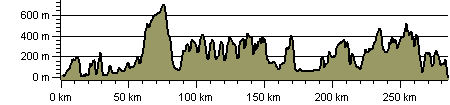
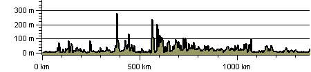
Heights along the way
The LDWA pages for Offa’s Dyke and the Wales Coast Path include profiles:This includes a route profile for Offa’s Dyke:
Offa’s Dyke route profile
Wales Coast Path route profile (anti-clockwise, north to south)
