
The British Library are asking the public to geo-reference their collection of maps. Just as I’ve described about local maps in maps of the imagination and in the maps section of this site, even maps designed to be ‘accurate’ in their time differ from modern mapping. This project asks members of the public to geo-reference these maps aligning control points on the old map with points in Google Earth.
Henry Graber of The Atlantic had a go, and describes the experience, and more about the project in his piece “Good Deed of the Day: Help Geo-Reference the British Library’s Map Collection“. This is his alignment of an 1857 map of Alexandria:

Alexandria – old map from British Library collection superimposed on Google map
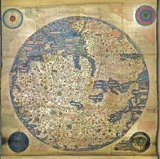
Even if you don’t do any geo-referencing of your own, while you are at the British Library site, take a peek at their Magnificent Maps exhibition, which most definitely lives up to its name. It includes the Fra Mauro mappa mundii that is described in James Cowan’s “A Mapmaker’s Dream“, which I have referred to so much over the years.
Great article – I shared this on Google Plus 🙂
The Scottish Library looks good for georeferenced maps too – http://maps.nls.uk/
Thanks Chris, the Scottish library maps are great – looking up maps of Tiree! On my shelves I have a large format book “Togail Tir – Marking Time” all about maps of the western isles, and as I scan through the NLS site, can see many familiar ones from that.